I don't remember claiming Vercingetorix coins were forgeries though presumably most coins are a palimpsest, melting and remoulding them being as easy as correcting/altering a piece of parchment.
Not surprised to read about the 'Jurassics', the canton of Jura wants to break away from the rest of Switzerland. They claim to speak the purest French.
Finally got round to looking up Alesia which has apparently engendered a lengthy and still unresolved etymological argument. One side seems to favour a 'hydronym' breaking the name into Al- and -Is, the other camp prefers an 'oronym' claiming alaise means rocky place, cliff, crag, etc. My first thought when Alese places came up was "island-hopping" because of Is/Ys, but it seemed a bit far-fetched at the time.
Strangely, I was looking at Gaztelugatxe, an island attached to the Spanish coast half-way between Santander and San Sebastian, as part of an on-going obsession.
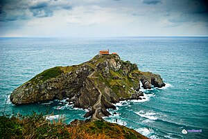
According to Wiki the name means something like 'castle on the crag' (the castle is in fact a hermitage dedicated to John the Baptist, a great Megalithic favourite):
The word gaztelugatxe comes from the Basque gaztelu = "castle" and aitz = "rock" or "crag", forming "crag of the castle".
which reminded me of the islets in the Thames known as aits so I wondered whether there was any connection between alese and axle, if the letters were transposed. Anyway, route-marking 'islands' might be seen as axles or axis [Aix place-names?].