Megalithic mapping

Current topics

Re: Megalithic mapping

Postby Boreades » 12:43 pm

macausland wrote:Am I right in thinking that the numbers under the fractional headings refer to lines of latitude?

Correct.

macausland wrote:By the way, there is a theory that we don't actually go round the sun as such but follow the sun in a spiralling orbit as the sun itself moves along its orbit within the galaxy.

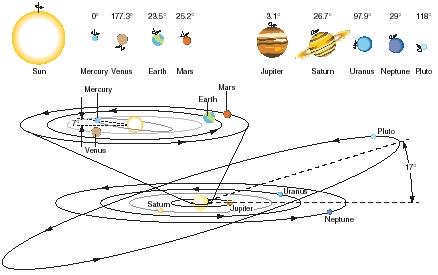
Not theory, fact. From a "static" point-of-view far enough out into space (external to our own Solar System), all the planets would look like they are corkscrewing their way through space, following the sun on its own orbit through our local galaxy. But from our point of view, we're all moving in a relatively flat plane around the sun. Except for Pluto, which is not significant.

Image

macausland wrote:If this is correct would this affect the calculations of the MAGI or would it make no difference?

It makes no difference over days, weeks & months, or a few decades. But over a few thousand years, it does.

Image

"The sun is the same in a relative way, but you're older."
Boreades
 
Posts: 2084
Joined: 2:35 pm

Re: Megalithic mapping

Postby Mick Harper » 12:49 pm

For those of you desperate to hear about the forthcoming Harper/Vered Space DVD, it says that
a) for a basic understanding of the Solar System it is essential to understand that the earth does not in fact go round the sun but corkscrews round the galaxy
b) Pluto very much makes a difference and
c) the Precession of the Equinoxes is a total myth.
So one out of three, Borry.
Mick Harper
 
Posts: 910
Joined: 10:28 am

Re: Megalithic mapping

Postby Boreades » 1:03 pm

As a footnote, if you ask most folks in the UK where "our" decimal number system came from, the most common answer whould be "Arabic". In fact, the Arabs got the decimal number system from India.

It maybe relevant that : "the earliest references to astronomy are found in the Rig Veda, which are dated to c.2000 BC. Some Vedic notices mark the beginning of the year and that of the vernal equinox in Orion. This was the case around 4500 BC. Yajnavalkya (perhaps 1800 BC) advanced a 95-year cycle to synchronize the motions of the sun and the moon.A text on Vedic astronomy that has been dated to 1350 BC, was written by Lagadha. In 500 AD, Aryabhata presented a mathematical system that took the earth to spin on its axis and considered the motions of the planets with respect to the sun (in other words it was heliocentric). His book, the Aryabhatya, presented astronomical and mathematical theories in which the Earth was taken to be spinning on its axis and the periods of the planets were given with respect to the sun. Aryabhata wrote that 1,582,237,500 rotations of the Earth equal 57,753,336 lunar orbits. This is an extremely accurate ratio of a fundamental astronomical ratio (1,582,237,500/57,753,336 = 27.3964693572), and is perhaps the oldest astronomical constant calculated to such accuracy.Brahmagupta (598-668) was the head of the astronomical observatory at Ujjain and during his tenure there wrote a text on astronomy, the Brahmasphutasiddhanta in 628. "

Ref: http://www.crystalinks.com/indiastronomy.html

So I wouldn't be at all surprised to find some sites in India that fit what we're looking for.
Boreades
 
Posts: 2084
Joined: 2:35 pm

Re: Megalithic mapping

Postby macausland » 1:24 pm

I've come across this site which may be useful in your latitudinal endeavours. Or it may not.

However

http://www.ancient-wisdom.co.uk/xavierguichard.htm

The article has an informative resume on Xavier Guichard's book "Eleuse Alaise: Enquête sur les origines de la civilisation européenne" [Investigation of the origins of European Civilization]

His book which is linked on the site in full, and in French, details his idea of ancient map makers building maps from a couple of central points with lines radiating out. Placenames are followed along the lines and many examples are given relating to Alaise, Elysian etc. Even Leeds gets a mention.

I'll have a good dig into it and see if there is anything relevant to latitudes. One section of the book, somewhere towards the end is all about his maps so not much knowledge of French is needed. It's mostly pictures, placenames and maps.

His theory reminds me of other posts on here in which ancient maps were shown, all drawn in a similar way, using central points in the middle of circles and radiating out.

Here's a quote from the Ancient Wisdom site which sums it up.

'Guichard claimed to have discovered two prehistoric 'rose des vents' covering France and extending into other parts of Europe, based on 24 landscape alignments (corridors of incidence), all orientated so as to pass through a common centre-point (called Alaise). Secondly, he identified three European 'root' names; Burgos, Antium, and Alaise, which he believed (similar to his UK counterpart, Alfred Watkins) had different meanings associated with ancient mineral sources and trade, but more controversially, that the 'Alesian' locations had been placed according to their longitude and latitude.

Alaise was the hub of an archaic, yet very precisely surveyed, radial system of 24 ley lines which emanated from Alaise, in all directions, one ley line every 15 degrees of 360, and along these 'ley-lines' were also located ancient settlements named with etymological affinity to the town-name of the ley line system’s hub, Alaise...

Guichard also claimed to have found evidence of a separate 'solstice rose des vents' at Alesia, based on solar observations, creating a valuable connection between prehistoric geometry and astronomy, (and from which it may still be possible to date such a formation). He concluded that he had uncovered the vestiges of what had been called the 'Eleusian mysteries' by the Greeks. It is perhaps just a coincidence that both Stecchini and Guichard (supported by Manias), independently concluded that the true secret of the mysteries involved the application of longitude in relation to the placement of ancient and sacred sites. (More about the Eleusian mysteries below).'

Here's a link to the map section in his book as on the above site.

http://www.ancient-wisdom.co.uk/eleuse% ... pter14.htm
macausland
 
Posts: 339
Joined: 3:17 pm

Re: Megalithic mapping

Postby macausland » 4:59 pm

Further east in northern Kazakhstan 'Live Science' reports the discovery of about fifty giant geoglyphs as seen on Google earth.

These are being investigated more closely by scientists.

http://www.livescience.com/47954-geogly ... hstan.html

It doesn't state exactly where but the most northern part of the country is at about 54 degrees latitude. Will this fit in with the fractions etc?
macausland
 
Posts: 339
Joined: 3:17 pm

Re: Megalithic mapping

Postby hvered » 10:11 am

The Guichard investigations are most exciting, the number of Alesia-related names he marked on or near his lines are extraordinary.

Alesia came up in the Graham Robb book, whether independently or not I don't know, and according to Wiki there've been arguments raging over which Alesia was the location of Vercingetorix's defeat: " In total, around 40 towns and other locations have claimed to be the site of Alesia."

Are 'Eleusian' names e.g. Lis/lys/lice all about light or, in megalithic terms, do they indicate beacon hills? The one I am familiar with is Ellesborough which has a very nice pub and overlooks the Ridgeway/Icknield Way (the footpath to said pub crosses the front lawn of Chequers).

The road from Wendover to Princes Risborough, which makes a very clearly defined detour around the hill on which Ellesborough Church stands, follows the route of the Icknield Way, an ancient trackway used by man in the neolithic age (3000 to 1800 BC) which ran from Norfolk to Avebury in Wiltshire.


The St Peter and St Paul church-on-a-hill suggests Ellesborough is indeed a 'light' place rather than 'pasture for asses' as the official etymology has it. In fact the Wiki article goes on to describe the topography in more detail:

Towering over the village is the dominating Beacon Hill, with its grassy mound and lone tree, iconic amongst the Chiltern Hills when viewed from within the Aylesbury Vale. It is also the site of Cymbeline's Mount, also known as Cymbeline's Castle, referred to in the Shakespeare play Cymbeline. In reality, the name refers to the British King Cunobelinus who, alongside his sons, is said to have battled at this site against the Roman Invasion of the British Isles. It is the site of a medieval motte and bailey castle.


Lycée means school, academy, in French; the etymology is (naturally) Classical i.e. "From Latin lyceum, from Ancient Greek Λύκειον (Lúkeion) (the name of a gymnasium, or athletic training facility, near Athens where Aristotle established his school)" and, rather oddly, is claimed to derive from 'wolf-killer'. The French Lycée in England is appropriately enough in South Ken, the museum heartland of London, on the prehistoric A4 route leading to St Paul's.
hvered
 
Posts: 855
Joined: 10:22 pm

Re: Megalithic mapping

Postby hvered » 11:08 am

P.S. Cymbeline Mount seems to be based on Kimble, there's a Great Kimble and a Little Kimble north and south of Ellesborough. Great Kimble is the site of a prehistoric hillfort on Pulpit Hill and the Ridgeway passes the foot of this hill before continuing north-west to Ellesborough's Beacon Hill and (the remains of) Cymbeline's Castle.
hvered
 
Posts: 855
Joined: 10:22 pm

Re: Megalithic mapping

Postby macausland » 1:20 pm

That's interesting about Pulpit Hill.

In the maps, the first deviation from the meridian line passes over Mont Poupet. I wonder if there is a connection?

If I may go off at a tangent myself and probably quite wrong but I would assume that whoever devised this remapping was working after the ice age.

The names they gave to points would be in their own language whatever that was.

They were obviously skilled in mathematics and all related disciplines and were clearly not 'savage cavemen'.

Where did they come from? Were they survivors of the ice or were they possibly from regions that had not been touched by the ice and had come to redraw the new maps once it was useful to do so? Middle East? Far East?

I assume they sited landmarks along each projected line and gave them the names to go down in the record hence the similarity in names at determined points.

Did the names consist of numbers, line one, line two etc? Were they mnemonics? I would assume there would be a logic in the choice of name. Would it be possible to reconstruct a part of the language used from this information?

What part do local legends play in describing what was actually going on? Are the legends just one step away from the reality of the situation?

The work involved in this mapping would require not only the experts doing the thinking and calculations but also a large labour force to build markers etc at selected points. Was a local population 'seeded' at each point rather like Greek colonists? They would be responsible for maintaining the markers. Presumably they would live off the surrounding land which in itself would possibly require a division of labour. Those doing the maintenance and those doing the food collection etc. Perhaps the local Count or Compte or whatever really was a counter, and so on.

I've just checked the online French dictionary. Alese (not sure how to do the accent) (f) is an 'undersheet or drawsheet'. Aleser is a verb meaning 'to ream'.

Anyway that's my twopennorth. Boreades will now fly in no doubt with the galactic fleet and blast these ideas with his razor sharp laser weapons.
macausland
 
Posts: 339
Joined: 3:17 pm

Re: Megalithic mapping

Postby Boreades » 9:37 pm

macausland wrote:I've come across this site which may be useful in your latitudinal endeavours. Or it may not.
However
http://www.ancient-wisdom.co.uk/xavierguichard.htm


Yes indeed, thanks!
I knew of the site, but had not noticed that page.

Their page on Prehistoric Greece
http://www.ancient-wisdom.co.uk/greece.htm
reminds me that
The site of the Delphine Oracle, arguably the most important oracle in the classic world and sacred since prehistoric times, originally being a shrine to Gaia and a centre from which sacred temples and oracle centres were placed apparently according to principles of longitude. Delphi is also associated with the worship of Apollo (the sun god), who is said to have killed the serpent Python at Delphi, essentially supplanting one form of worship with another. The sites status as an Earth Navel was recognised by Herodotus, who connected the oracle centre at Delphi with the one at Karnak in Egypt. both sites at which Omphalos stones have been found.

Delphi = 3/7ths, 38° 29' N
Karnak (Thebes) = 2/7ths, 25° 43' 0 N
Boreades
 
Posts: 2084
Joined: 2:35 pm

Re: Megalithic mapping

Postby Boreades » 10:07 pm

Amarna, Akhetaten
http://en.wikipedia.org/wiki/Amarna

Akhetaten means "Horizon of the Aten" (disc of the sun)
27.6 deg latitude
= 5/13ths

That would be a 5:12:13 triangle.
Familiar to anyone familiar with Stonehenge.
Boreades
 
Posts: 2084
Joined: 2:35 pm

PreviousNext

Return to Index

Who is online

Users browsing this forum: No registered users and 165 guests