Megalithic mapping

Current topics

Re: Megalithic mapping

Postby TisILeclerc » 1:06 pm

'Burgh island in Devon?'

Probably but not according to Irish legend or Wiki.

Wiki tells us that it means 'Bear Island'. And at least one online Irish dictionary gives us 'Bear' for Bear. Although the usual word for bear is 'math' or the generic 'Art' used in Welsh and other European languages.

https://en.wikipedia.org/wiki/Bere_Island

The word is spelled 'Bere' on the map so if we are going to stick to English forms why not call it 'Barley Island'? Or perhaps bear left here lads island or you'll run aground or maybe find buried treasure.

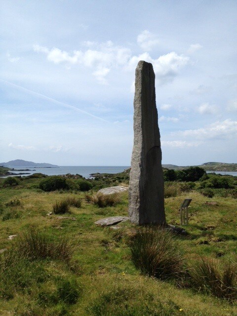
Irish legend tells us the tale of an Irish prince setting sail for Spain and coming back with a Spanish wife called Beara and gave the island her name in her honour.

'A Beara legend demonstrates the age-old traffic between the peninsula and the outside world. Eoghan mór, a 2nd century king of Munster was driven out of ireland by Conn of the Hundred Battles. Eoghan spent nine years in exile and married Beara, daughter of a Spanish king. Returning to regain his territory, he landed on a peninsula, which he named in honour of his wife.'

http://www.bearatourism.com/PDF%20files ... rt1%29.pdf

Looking at the map again it does look a bit like Cornwall with Bere Island a bit Isle of Wightish stuck in the middle of the south coast.

https://en.wikipedia.org/wiki/Dursey_Island

While just off the 'Lands End' bit we have Dursey Island. Could this be another Dur, Dor Durdle placename?

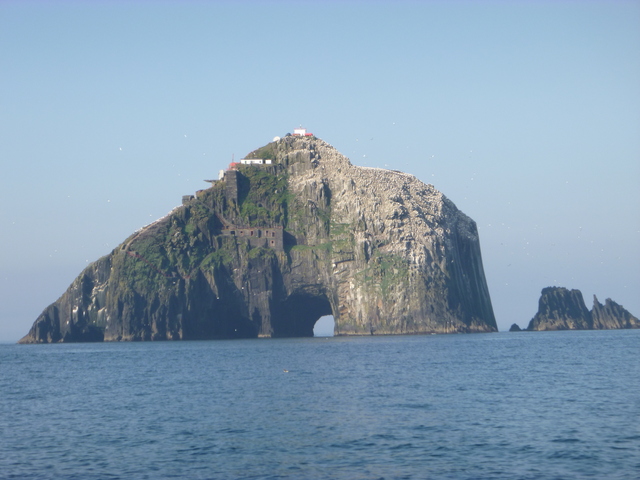
Wiki tells us that it is also called Baoi Bhéarra or Oileán Baoi in Irish. Baoi apparently means Buoy. Baoithe means unsteadiness or foolishness. Off the west coast there are tidal races and three offshore rocks called Bull, Cow and Calf. There is also a Crow Head.

The area is apparently the start of the E8 trans Europe walk to Turkey. It crosses to North Wales and then eastwards across England. It's a pity they didn't recommend a megalithic sailing route taking in all the old points of interest on the way. There must be an EU fund somewhere waiting to be milked.

Or perhaps the BBC will large out with the largesse. They're repeating an 'experiment' to see how Stonehenge was built using 'modern' methods which apparently an improvement on the methods the used the last time they tried it. Although I believe they didn't go to Wales to chip the stones out of the bedrock with antlers and bits of rock and drag them all the way to the 'launch site'.

http://www.bbc.co.uk/news/uk-england-wiltshire-30041330
TisILeclerc
 
Posts: 790
Joined: 11:40 am

Re: Megalithic mapping

Postby hvered » 11:25 pm

A small town on the Beara Peninsula, Castletownbere, has one of the 'largest natural harbours in the world' called Berehaven. Its outer harbour is claimed to be the second safest harbour in the world, protected by Bere Island to its south and the peninsula to the north. The inner harbour is connected by a bridge to Dinish Island to the south of Castletownbere

Image

Bere Island, 'Isle of Wightish' or not, is certainly a convenient structure in a significant location.
hvered
 
Posts: 855
Joined: 10:22 pm

Re: Megalithic mapping

Postby Mick Harper » 12:16 pm

Berehaven was an important British naval base before Irish independence. It would be interesting to find whether there is a correlation between such bases -- Scapa Flow, Loch Fine, Gareloch etc -- and Megalithia. As we've seen with Poole Harbour and Portsmouth all these so-called "finest harbours in the world" don't naturally cluster around the British Isles.
Mick Harper
 
Posts: 910
Joined: 10:28 am

Re: Megalithic mapping

Postby spiral » 8:02 am

The Cailleach Beara is a hag and a beautiful woman. She appears as a crone who asks a hero to sleep with her, when he does, she then transforms into a beautiful woman. She is ever-renewing and passes through many lifetimes going from old age to youth to old age. During her many lives she had at least fifty foster children. This is the creation myth of the tribes around Kerry and its surroundings. They are her children and her foster children.

see also

Cailleach Bheur, Bera, Bera, Scota, Scota, Boi, Boi, Old Woman, Old Woman of Beara, Cailleach Bhearra, Cailleach Bhearra, Cailleach Bui, Cailleach Bui, Cailleach Mov, Cailleach Mov, Caillech Bherri, Caillech Bherri, Hag of Beara, Hag of Beara, Digdi, Digdi, Dirri, Old Woman (of Beara), Old Woman (of Beara), Old Woman of Dingle, Old Woman of Dingle, Manx Caillagh ny Groamagh, Manx Caillagh ny Groamagh, Scottish Muilearteach, Scottish Muilearteach, Scota, Scota, Muilearteach or Muilearteach.
spiral
 
Posts: 228
Joined: 8:10 pm

Re: Megalithic mapping

Postby hvered » 9:57 am

This is the Cailleach Beara, or Hag of Beara

Image

A not particularly prepossessing rock, its shape is reminiscent of a mooring post. It stands above Ballycrovane harbour just north of Eyeries (on the Michael line) and in folklore is connected to the ebb and flow of tides. Ballycrovane is best known for a menhir called the Ballycrovane Ogham Stone, reputed to be the tallest in the world.

Visitors report the Cailleach Beara is adorned by an array of idiosyncratic offerings ranging from hair pins to mobile phones. A modern equivalent of harbour dues perhaps.

The Hag of Beara is said to have lived on Kilcatherine Point, appropriately since Catherine aka Hecate is the quintessential hag.

Image
hvered
 
Posts: 855
Joined: 10:22 pm

Re: Megalithic mapping

Postby hvered » 11:06 am

Dursey Island on the south-west edge of the Beara peninsula is separated from the mainland by a tidal race, the Dursey Sound, but seems to have been something of a lighthouse. Before actual lighthouses were built, first on the Calf and then on the Bull rocks to the west of Dursey, various churches e.g. Kilmichael, established by monks from Skellig, a 'house on a white rock' and a nineteenth-century signal tower were constructed.

The people on the Island lit fires when passenger ship going for America with people from the island or people who had Dursey connections on board the last sighting was the smoke from this point. Great grand children of those who emigrated on return visit to Dursey the most handed down memory to them was their last sight of Dursey was the smoke from the Tower.


Bull Rock has a striking archway or tunnel through the centre of the rock which looks entirely man-made, and recently.

Image

The small island west of Eyeries where the line passes is Scariff Island. It's a bird colony inhabited by the usual seabirds and, more unusually, choughs, sometimes called 'sea crows'.
hvered
 
Posts: 855
Joined: 10:22 pm

Re: Megalithic mapping

Postby hvered » 6:18 pm

The Ballycrovane standing stone, 17 feet high and reputedly the tallest menhir in Ireland, overlooks a small harbour at the head of the inlet [something we noticed with the 'Scottish meridian'], one of the westernmost points of Ireland. (Another menhir is at Dingle, further north, which is officially Ireland's most westerly harbour)

Image

Leaving Ireland at the Galleyhead lighthouse, the Michael line reaches the Cornish peninsula a mile north of High Cliff, Cornwall's highest cliff, and on to the French coast at Cap d'Antifer, "a prominent cape fronted by a steep cliff" 2-3 miles south of the better-known Etretat.

An octagonal-shaped lighthouse stands on the 'right' spot

Image

The cliff face here is just as remarkable as the Bull Rock in Ireland

Image


The point where the line crosses Cap d'Antifer is marked on Google Earth as a pigeon-loft, rather appropriately.
hvered
 
Posts: 855
Joined: 10:22 pm

Re: Megalithic mapping

Postby hvered » 8:27 am

Another 'Alese' place of interest is Lissewege, on the north coast of Flanders where the Cistercians established the 'polder abbey' of Ter Doest, daughter house of Our Lady of the Dunes further to the west.

Lissewege was a waystation on the Santiago de Compostela route. In addition to the Compostela connection, it's on the east-west Stonehenge - Goseck line. Wege means 'way'.

The traditional story of Lissewege lighting a roof-top fire to guide ships through to the harbour is pooh-poohed by Wiki which points out that roofs were made of straw and the whole village would be set alight. There appears to have been an offshore tidal island, not easy to make out on Google maps since the port of Zeebrugge took over, which would validate the folklore.
hvered
 
Posts: 855
Joined: 10:22 pm

Re: Megalithic mapping

Postby TisILeclerc » 3:30 pm

The Lissewege website claims that the place is named after the house of a 'Celtic' leader.

'The name LISSE-WEGE is supposedly derived from the words LISO (the name of a Celtic leader) and WEGA (wich is Celtic for house). From the beginning of the 12th century, the 'Lords of Lissewege' lived at the Upperhof, a fortified tower or keep on a surrounded by a double moat. In 1106, Lord Lambert of Lissewege donated a piece of land with a chapel to the Benedictine monks of St-Riquers in Ponthieu (France). This donation enabled the construction of the priory of Ter Doest.'

Where they get that from I don't know. The online Vandale dictionary tells us however that 'lis' means either 'flag' or 'iris' (the plant). It may well be that there was a signal station of sorts on the site. Perhaps flags during the daytime and lights at night. Although 'lys' appears to be Norwegian for light and Dutch and Danish as well.

http://www.lissewege.be/
TisILeclerc
 
Posts: 790
Joined: 11:40 am

Re: Megalithic mapping

Postby Mick Harper » 3:45 pm

We've established elsewhere that lys (as in fleur-de-lys) has a lily connection, probably ultimately derived from the Blue Lily, a narcotic found in ancient Egyptian tombs. So what's the botanical (or other) connection between lillies and irises?
Mick Harper
 
Posts: 910
Joined: 10:28 am

PreviousNext

Return to Index

Who is online

Users browsing this forum: No registered users and 112 guests