Megalithic mapping

Current topics

Re: Megalithic mapping

Postby hvered » 12:20 pm

Another site guarded/inhabited by witches and fairies is the 'curiously conical' hill of Dunadd which has a spring or well near its crest that is said to rise and fall with the tides.

This is also the case with the well at Roche St Michael, a similarly conspicuous hill in Cornwall. It may be that one of the resident hermits' jobs was to light a beacon to guide sailors, both Dunadd and Roche being visible from the sea.
hvered
 
Posts: 855
Joined: 10:22 pm

Re: Megalithic mapping

Postby TisILeclerc » 1:44 pm

Is that the Faery Folk that were caught by the Trossachs?


Nobody likes being caught by the Trossachs.

The crannog I was referring to is just off the shore of Loch Tay in Perthshire. A reconstruction has been done of it.

Image

They do get about a bit but they tend to like where they are really.

Like the Yorkshire Boggat who plagued a farmer and his wife so much they decided to move. They loaded the cart up with their possessions and set off. At the end of the lane they stopped and looked back at their home for the last time. The farmer said 'Aye lass, I think ah'll miss t'owd place.' His wife agreed. And from the back of the cart a little voice piped up 'Aye, we'll certainly miss it that's for sure.' The farmer turned the horse round and headed back.
TisILeclerc
 
Posts: 790
Joined: 11:40 am

Re: Megalithic mapping

Postby spiral » 8:56 am

TisILeclerc wrote:The crannog I was referring to is just off the shore of Loch Tay in Perthshire. A reconstruction has been done of it.
Image

It's a wee little thing, made of wood, so it will suffer awful damp, mould and rot all the year round. Presumably it had a raging hearth in the middle to keep folks toasty......
spiral
 
Posts: 228
Joined: 8:10 pm

Re: Megalithic mapping

Postby Boreades » 6:13 pm

spiral wrote: Presumably it had a raging hearth in the middle to keep folks toasty......


Good for smoking salmon, trout and eel.
Not much good for anything else.
Boreades
 
Posts: 2084
Joined: 2:35 pm

Re: Megalithic mapping

Postby Mick Harper » 9:24 pm

A good idea but why would you go to the expense of building your smoke house out in the lake? Think of an economic/technical reason. Or taste reason of course. We must not assume that ancient people didn't savour the finer things of life.
Mick Harper
 
Posts: 910
Joined: 10:28 am

Re: Megalithic mapping

Postby Mick Harper » 9:26 pm

Thought of one. The wood would always be damp.
Mick Harper
 
Posts: 910
Joined: 10:28 am

Re: Megalithic mapping

Postby TisILeclerc » 10:30 am

Image


According to wiki the earliest 'crannog' in Scotland is actually an artificial islet in North Uist. It looks very much like the causeway islands built into the sea discussed elsewhere. Complete with causeway. 'Cabhsair' in Gaelic.

This islet has been dated to about 3,000BC because of pottery finds which seem to connect it to Orkney.

https://en.wikipedia.org/wiki/Eilean_D%C3%B2mhnuill

Wiki tells us that there are over a thousand crannogs in Ireland. Apparently their are several interpretations of the word.

The obvious ones refer to young trees which were used in the construction, although some were built with stone. Other interpretations of 'crannag' include crow's nest, pulpit, churn, box, vessel etc.

https://en.wikipedia.org/wiki/Crannog

Interestingly Dwelly gives the following for a tidal causeway.

'dòirlinn /dɔːRLʲɪNʲ/
boir. gin. -e, iol. -ean
1 tidal causeway 2 tidal island (that can be reached via a tidal causeway or wading over an isthmus)'

I say interesting because it contains the 'dor' element which crops up around the coast such as at Durdle Dor.
TisILeclerc
 
Posts: 790
Joined: 11:40 am

Re: Megalithic mapping

Postby hvered » 1:03 pm

TisILeclerc wrote: 'dòirlinn /dɔːRLʲɪNʲ/
boir. gin. -e, iol. -ean
1 tidal causeway 2 tidal island (that can be reached via a tidal causeway or wading over an isthmus)'

I say interesting because it contains the 'dor' element which crops up around the coast such as at Durdle Dor.

We first came across doirlinns in connection with the causewayed Davaar Island, linked at low tide by the Dhorlin/Doirlinn to Campbeltown, the whisky capital of the Mull of Kintyre.

Doirlinn causeways seem to be shingle, or gravel, and cropped up at intervals when we investigated the meridian further north e.g.

Image

Other 'Eilean Traighe' islets were noted, it isn't clear if they're crannogs or not though they occupy apparently strategic positions. Another feature is Tarbert (portage) place-names, one Tarbe(r)t being at the tip of Loch Lomond, manned by whishky-sodden tollkeepers probably.
hvered
 
Posts: 855
Joined: 10:22 pm

Re: Megalithic mapping

Postby hvered » 11:30 am

TisILeclerc wrote:Guichard remarks in his book that many if not most of the Alesias are on peninsulas with a couple at least of rivers flowing around it but all of them are located at mineral water springs or wells. Source in French hence sourcier or sorcerer.

He is adamant that the names of all these locations are not French or Latin based and are found in all countries in Europe. They are pre Roman, pre Celtic and he claims that they are from a language dating back to the Stone Age.

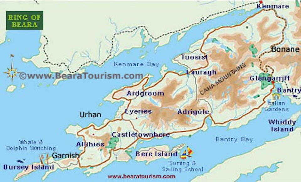
Allihies, on the south-west tip of the Beara peninsula in Ireland, is supposed to mean 'cliff-fields' or something but I wondered if it counts as an 'Alesia'.

According to Wiki Allihies has been at the centre of copper mining in Ireland since at least the Bronze Age, right up to the late nineteenth century. The village has a copper mining museum though obviously most of the structures are relatively modern.

More pertinent mapping-wise, the village is a mile or so south of the so-called Michael-Apollo Line from Skellig Michael to the Lebanese ports of Tyre and Sidon, possibly to Jerusalem. The point where it reaches the Beara peninsula crosses a sandy beach or cove, rather unexpected on such a rocky coastline.

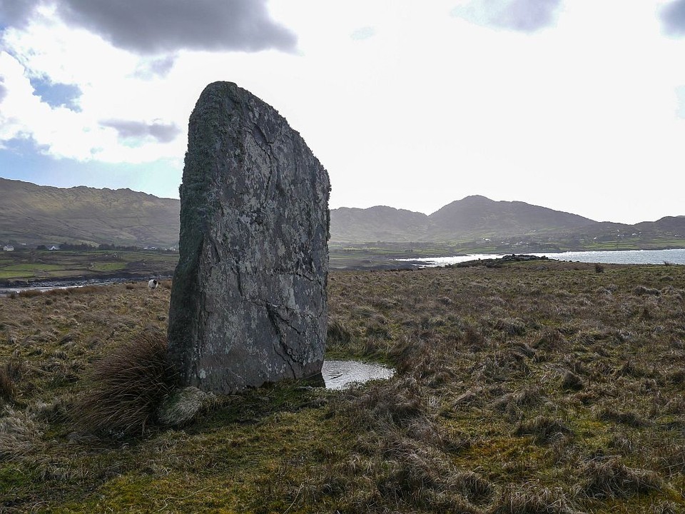
At the very western end of the Beara peninsula is a dolmen on flat ground close to the shore; a few feet south-west of the line, a small promontory juts out with a standing stone pointing north-west towards Skellig Michael which is visible, probably only occasionally in view of Irish weather.

Image
hvered
 
Posts: 855
Joined: 10:22 pm

Re: Megalithic mapping

Postby Boreades » 10:30 pm

The Beara peninsula also has a Bere Island
= Burgh Island in Devon?

Image
Boreades
 
Posts: 2084
Joined: 2:35 pm

PreviousNext

Return to Index

Who is online

Users browsing this forum: No registered users and 79 guests