New Views over Megalithia

Current topics

Re: New Views over Megalithia

Postby hvered » 8:32 am

Just seen Orkney mentioned in the Journal of Antiquities

On Gyre Road at Orphir Bay and a few hundred metres or so north of the shoreline of Scapa Flow, Orkney, are the remains of an early 12th century round church (kirk) of St Nicholas. It was probably originally dedicated to Saint Magnus. Beside the old church are a burial ground and the scant ruins of the Earls Bu, a Viking hall or palace, and also a farmstead and mill. The famous round church was built by Earl Hakon, who had a few years earlier (1111) murdered Earl Magnus (St Magnus). There is the Orkneyinga Saga Centre on the site; while in the burial ground there is an early medieval graveslab, and from the Dark Ages a Pictish symbol stone.


An author called J. Gunn wrote in 1941 that the church was used as a pilgrim stopping point. By pilgrims he presumably meant mariners. Mr Gunn goes on to say that

after murdering Earl Magnus he: “……endeavoured to expiate his crime, as the manner then was, by going on a pilgrimage first to Rome and thereafter to Jerusalem. A small but deeply interesting fragment of masonry, still to be seen in Orphir churchyard, is regarded as a memorial of that penitential journey. At the east end of the present church (now demolished) is a vaulted semicircular apse of what was once the Round Church of Orphir, one of the very few churches in Britain built on the model of the Church of the Holy Sepulchre in Jerusalem. It seems certain that this was erected by Hakon on his return to Orkney, and it is therefore the oldest piece of ecclesiastical building in Orkney, except, perhaps, some of the ruins of little Celtic chapels.”

https://thejournalofantiquities.com/201 ... ney-isles/

Hakon is supposed to mean something like 'high son' in Swedish and Norwegian. English equivalent would be Prince.

The Orkneys have an invaluable asset, the sheltered harbour of Scapa Flow, so well worth laying claim to and protecting. The Journal article gives an interesting detail on the name (and function?) of this round church

The site entry for Orphir: St. Nicholas’ Church in ‘Ancient Monuments – Scotland’ adds that: “Only the chancel and a small part of the nave remain of this, the single example of a round church known to have been built in the Middle Ages in Scotland. The structure dates from the twelfth century, and appears to have been modeled on Scandinavian prototypes, derived ultimately from the Church of the Holy Sepulchre at Jerusalem.” Also we have Charles Tait writing in 1999. He adds some more information saying: “The Round Kirk is thought to be the church built by Earl Haakon Paulson, to the plan of the Church of the Holy Sepulchre, on his return from Jerusalem about 1120, in atonement for the murder of Earl Magnus. Previously known as the Girth House from the Norse grid for sanctuary, or peace, the church was largely demolished in the 18th century (about 1757) to build a new church, itself now gone.”

Grid has other associations apart from 'sanctuary or peace'.
hvered
 
Posts: 855
Joined: 10:22 pm

Re: New Views over Megalithia

Postby Mick Harper » 11:05 am

Not strictly relevant but another Hakon arrived in Scapa Flow in 1940 (King Haakon VII fleeing from German-occupied Norway). And speaking of what goes round ... what prevents the Church of the Holy Sepulchre in Jerusalem being modelled on the Round Church of Orphir?
Mick Harper
 
Posts: 910
Joined: 10:28 am

Re: New Views over Megalithia

Postby Boreades » 10:14 pm

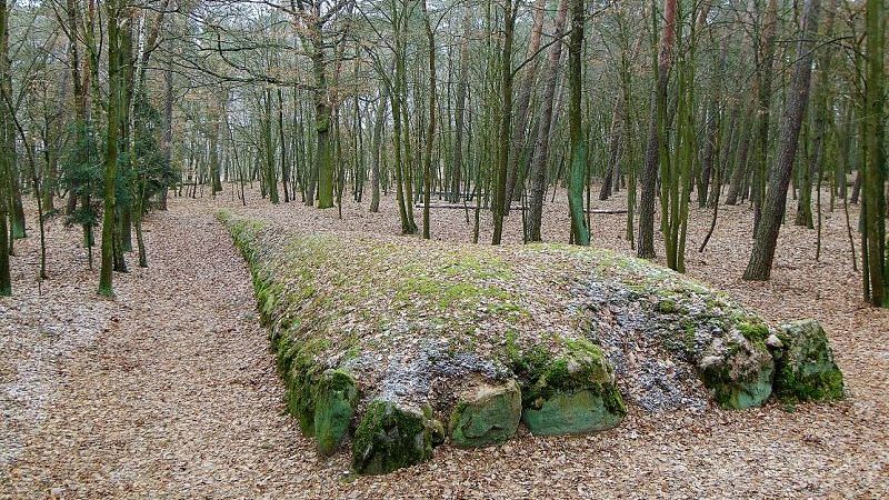
News about a Polish megalithic site, in the Góry forest in Eastern Wielkopolska.

Image

“The earthen mounds of the Góry megaliths are up to 90 meters long and 1.5 meters high and are in a very good state,” reports a press release of the Foundation Development YES – Open Pit MinesNO (DY-OPMN), an organization dedicated to their preservation. “Only the outer stones had been removed through ages of farming in the region. The rest is virtually intact.” The Foundation reports that there are 15 tombs, including 14 long-barrow tombs of the Neolithic Funnelbeaker culture, and one Lusatian culture tomb dated to the Early Bronze age at about 3 thousand years ago. They have remained to this day largely unexplored and unexcavated by archaeologists, save for initial survey. But once investigated, they could emerge as one of the most important sites of megalithic culture in Europe, joining discoveries such as Grønsalen on the Isle of Man in Denmark, Brú na Bóinne in Newgrange, Ireland, West Kennet Long Barrow in England, La Roche aux Fées and the Carnac Stones in France, and the megalithic temples of Malta.


It may, however, be dug up and discarded to make way for an open cast coal mine.

But these tombs also sit atop a coal deposit — a deposit that Poland’s ZE PAK mining company (through the planned Ościsłowo open-pit mine) is very keen to exploit — and as soon as possible. It is a familiar story. There are others like this one out there: the Mes Aynak site in Afghanistan is one high profile example.


http://popular-archaeology.com/issue/fa ... estruction

In case some think this is just silly foreigners (in a far away land) making a fuss, perhaps we should recall what happened to the Dorchester Henge (disappeared by gravel extraction). Or the Thornborough Henges.

Extensive quarrying has destroyed much of the monument's setting to the north and west of the henges. The site lies within the wider Nosterfield quarry area being exploited for gravel by Tarmac Northern Ltd. Although the henges themselves are not threatened, Tarmac now wishes to extend its quarrying operations to a 45 hectare site less than a mile east of the henges known as 'Ladybridge Farm'.


I suppose it's a good job Stonehenge is a UNESCO World Heritage Site and protected. It's not like (say) they could build a dual carriageway road through the site?
Boreades
 
Posts: 2084
Joined: 2:35 pm

Re: New Views over Megalithia

Postby Boreades » 6:16 pm

♫ ♪ ♫ ♪ ♫ ♪ ♫ ♪ ♫ ♪ ♫ ♪ ♫ ♪ ♫ ♪ ♫ ♪ ♫ ♪ ♫ ♪ ♫ ♪ ♫ ♪ ♫ ♪ ♫ ♪ ♫ ♪ ♫ ♪ ♫ ♪
All around my hat I will wear the green willow
And all around my hat for a twelve month and a day
And if anyone should ask me the reason why I'm wearing it
It's all for my true love who's far, far away.

♫ ♪ ♫ ♪ ♫ ♪ ♫ ♪ ♫ ♪ ♫ ♪ ♫ ♪ ♫ ♪ ♫ ♪ ♫ ♪ ♫ ♪ ♫ ♪ ♫ ♪ ♫ ♪ ♫ ♪ ♫ ♪ ♫ ♪ ♫ ♪


Your big festive chance to make something special, in Avebury, for your megalithically-significant other person.
Date and Time: Thu 7 December 2017, 10:00 – 12:30 GMT
Location: Avebury, SN8 1RF

I'm told that "the Willow Wreath Workshop is a very popular event, so to avoid disappointment, make sure you book early!"

This year our willow wreath workshop will be led by talented sculptress Charlotte Moreton, so all the more reason to join us for a half day workshop to design and make a Christmas wreath for your front door. Get into the festive mood and get creative with willow! Light refreshments and all resources provided. Tickets are £30 per person to cover tuition, all materials, and refreshments.


Image

Here's one we prepared earlier.

Image

More here : https://www.eventbrite.co.uk/e/willow-w ... 9389498049

On a more industrial scale, many a willow fence was weaved to keep livestock inside the hilltop enclosures.
Boreades
 
Posts: 2084
Joined: 2:35 pm

Re: New Views over Megalithia

Postby Boreades » 3:50 pm

Tut, after all we've done to feed him material, not even a passing mention of TME and our broch work? :-(

Scottish historian, author and filmmaker, Ashley Cowie, teams up with Iron Age specialist Iain Maclean seeking evidence of an ancient system of long distance communication between Caithness brochs.

https://ashleycowie.com/new-blog/secret ... e30d142156
Boreades
 
Posts: 2084
Joined: 2:35 pm

Re: New Views over Megalithia

Postby Mick Harper » 7:30 pm

I have just watched this. Most illuminating. Although they seem to be mildly obsessed with the military side of things (perhaps unavoidable up there) it is fairly clear that the line of sight from broch to broch is for travel and trade rather than as warning signals. A bonfire does that just as well. The (very expensive) brochs would seem more likely to be defensible storage dolmens.

The other big difference between oop there and dahn sarth is that there hardly seems one way through, on the evidence of their travails in the film, rather than the infinite number of routes southern Megalihics had to select their way among. That is presumably why line of sight is a series of doglegs rather than the straight line system we are used to.

It will have occurred to all of you that our (very nascent) work on Irish Sea navigation links the two systems.
Mick Harper
 
Posts: 910
Joined: 10:28 am

Re: New Views over Megalithia

Postby TisILeclerc » 10:34 am

Image

http://www.scottishbrochs.com/brochs.html

Here's an interesting site for Broch collectors.

It appears that the majority are located near the sea, are mainly in the north east and the edges of the north west. Perfectly sited for markers or lighthouses around that coast.

Given the ancient origins of civilisation in Orkney it could be that brochs are, in origin, just as ancient. The MacLeod clan have a coat of arms showing fires on hillsides. Stolen it would appear along with everything else from the MacNicol or Nicolson clan who were hereditary watchers of the shores and coasts. It would make more sense to have these beacons enclosed in a draught free enclosure than on a bare hillside.

How ancient? Well given that Doggerland blocked the route to the south via the east coast it would be natural for travellers from northern Europe to take the northern route and down the west coast. The sinking of Doggerland can be seen perhaps like the digging of the Suez or Panama canals?

Now there's a thought. Was Doggerland deliberately sunk by early Vikings wanting a quick route to the south?
TisILeclerc
 
Posts: 790
Joined: 11:40 am

Re: New Views over Megalithia

Postby Boreades » 1:21 pm

Mick Harper wrote: they seem to be mildly obsessed with the military side of things (perhaps unavoidable up there) it is fairly clear that the line of sight from broch to broch is for travel and trade rather than as warning signals.


This is consistent with the "professional" historians who insist on talking about the "hill forts" on places like the Greater Ridgeway. Great for sexing-up the dossier, to make it more appealing as a TV series or a best-selling book, while ignoring the bigger picture and the more mundane and peaceful reality. Travel and trade continued for 100s if not 1000s of years, with only the occasional scuffles between the overlords who controlled the protection rackets (a.k.a. taxation). You need protection from the, err, other overlords.

If you want to climb the "professional" historians' status ladder, ignore the trade plebs, just focus on the "high-caste elite" stuff. Or, if you want to be historically accurate, and get up the elite historians' noses, keep posting on TME, and achieve a different kind of wealth. ;-)
Boreades
 
Posts: 2084
Joined: 2:35 pm

Re: New Views over Megalithia

Postby Boreades » 10:32 am

TisILeclerc wrote:Given the ancient origins of civilisation in Orkney it could be that brochs are, in origin, just as ancient. The MacLeod clan have a coat of arms showing fires on hillsides. Stolen it would appear along with everything else from the MacNicol or Nicolson clan who were hereditary watchers of the shores and coasts.


Some might concur; I'm not in an especially good place (emotionally) about this. Those MacLeods were predators on Clan Boreades as well. They have a well-documented history of stealing our wives and children. Or setting fire to them in caves.

TisILeclerc wrote:It would make more sense to have these beacons enclosed in a draught free enclosure than on a bare hillside.

Were the brochs dual-purpose? Some with a roof to keep the trade-hub/foundry warm and dry? Some without a roof to let the light out?

TisILeclerc wrote: How ancient? Well given that Doggerland blocked the route to the south via the east coast it would be natural for travellers from northern Europe to take the northern route and down the west coast. The sinking of Doggerland can be seen perhaps like the digging of the Suez or Panama canals? Now there's a thought. Was Doggerland deliberately sunk by early Vikings wanting a quick route to the south?

Must have seemed like a good idea at the time. Let's dig a small stream through the high ground between Dover and Calais. What could possibly go wrong?
Boreades
 
Posts: 2084
Joined: 2:35 pm

Re: New Views over Megalithia

Postby Boreades » 6:33 pm

At Château Boreades, we get visitors. This weekend saw the welcome return of an old favourite. She's been many times before, but I didn't realise until now that her day-job is a Medieval Historian, specialising in remedial tuition for kids with special needs. (Some might say, perfect for TME). Anyway, she showed me one of the books she's been using to get kids excited about history (after the regular teachers had done their damnedest to kill any joy the kids might have had in the subject)

King John: Treachery, Tyranny and the Road to Magna Carta

John was dynamic, inventive and relentless, but also a figure with terrible flaws. In two interwoven stories, we see how he went from being a youngest son with limited prospects to the ruler of the greatest dominion in Europe, an empire that stretched from the Scottish border to the Pyrenees.


It all started so well, and then...

We discover how, having lost most of his lands in France, he battled for the rest of his life to win them back. His rise to power involved treachery, rebellion and murder. His reign saw oppression on an almost unprecedented scale: former friends hounded into exile and oblivion; Wales, Scotland and Ireland invaded; harsh fines and huge taxes, the greatest level of financial exploitation since the Norman Conquest. A quarrel with the pope led to the king being excommunicated and England being placed under Interdict; for six years, the church bells remained silent and the dead were buried in unconsecrated ground. John's tyrannical rule climaxed in conspiracy and revolt, and his leading subjects famously forced him to issue Magna Carta, a document binding him and his successors to behave better in future. The king's rejection of the charter led to civil war and foreign invasion, bringing his life to a disastrous close.


Not that most of us would ever know it, limited as we are to endless films of him snivelling with the Sheriff of Nottingham while Robin Hood runs rings round them, and Ye Good King Richard was on a package tour of Palastine.

Exhibit one (m'lud) in said book is a map of his dominion (before he cocked it all up). It's almost a dead-ringer for a map of most of the Megalithic Empire, all down the western seaboard of Europe, from Scotland, through Ireland, Wales and England, down the west coast of (what we now call) France, down to the Pyrenees.

Image

The exam question is: why do these two territories have so much in common?
Boreades
 
Posts: 2084
Joined: 2:35 pm

PreviousNext

Return to Index

Who is online

Users browsing this forum: No registered users and 179 guests