Megalithic shipping and trade routes

Current topics

Re: Megalithic shipping and trade routes

Postby Boreades » 10:27 pm

True, only accessible by boat, now. But (we're told) back then you could have waded across at low tide, and Green Island was about 4x bigger.
Boreades
 
Posts: 2113
Joined: 2:35 pm

Re: Megalithic shipping and trade routes

Postby Mick Harper » 10:37 pm

I'm no expert on bracelets (it's the only subject on which I'm not) but doesn't it follow that if it's big enough to get over your hand it will be unwieldy on the wrist? Also a determined slave would get through shale in, I'm no expert, about thirteen hours and twenty-seven minutes.
Mick Harper
 
Posts: 929
Joined: 10:28 am

Re: Megalithic shipping and trade routes

Postby Boreades » 10:38 pm

If you ask Hattie nicely, she might let you borrow some of her jewellery. And matching garments.
Boreades
 
Posts: 2113
Joined: 2:35 pm

Re: Megalithic shipping and trade routes

Postby TisILeclerc » 11:02 am

http://www.bbc.co.uk/news/in-pictures-39254575

An interesting article about 'Britain's part time islands' with photographs by somebody who prefers to use real cameras and film.

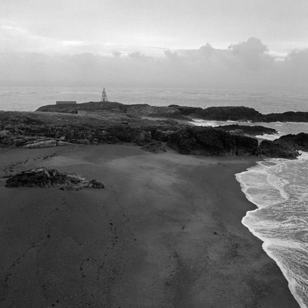
Taking care not find himself cut off due to the changing tide, Boardman visited a number of locations, including Hilbre Island in West Kirby, Ynys Llanddwyn off the coast of Anglesey and Piel Island in Cumbria.


Image

They seem to be conveniently west coast islands or part time islands.

Hilbre Island we are told, by wiki if that means anything, was actually one of three, pronounced Hilbree. And usually translated as 'eye' although we are told that one of them was called 'island' in a mediaeval manuscript. But, Eye, Ee, and Isle are probably related anyway.

And who occupied this place?

Hilbre Island's name derives from the dedication of a medieval chapel built on the island to St. Hildeburgh, an Anglo-Saxon holy woman, after which it became known as Hildeburgheye or Hildeburgh's island.[4] Hildeburgh is said to have lived on Hilbre Island in the 7th century as an anchorite. Some consider that she never existed, while others equate her with Saint Ermenhilde, the mother of Saint Werburgh to whom Chester Cathedral is dedicated,[5] or St Edburga of Mercia, daughter of the pagan king Penda.


I'm sure the name Ermenhilde may awaken memories.

The other two islands in addition to Hilbre itself are Little Eye and Middle Eye.

https://en.wikipedia.org/wiki/Hilbre_Islands

Traipse a bit further north and hanging off Furness is Piel island which also had a collection of religious characters looking after it. This is also one of a series of islands.

Image

Image

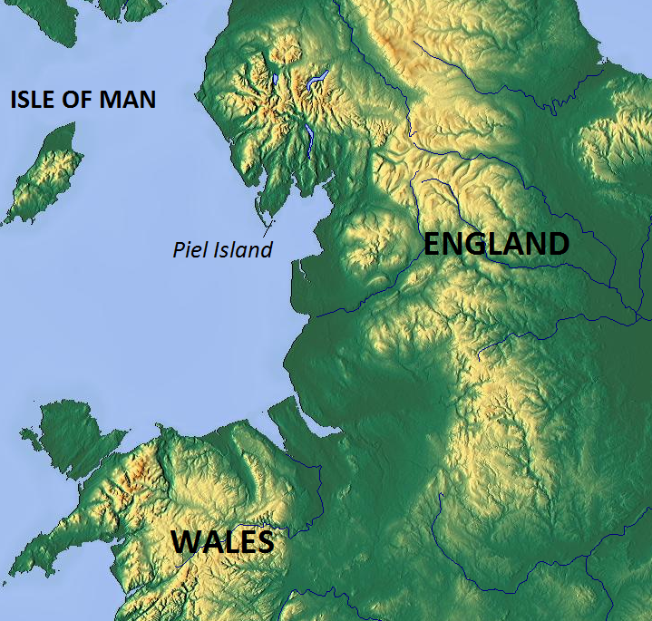
In the Middle Ages Piel was known as Fowdray (or Fouldrey or Fowdrey) island. This name would seem to be derived from the Old Norse words fouder, meaning "fodder", and ay or oy, meaning "island". The island's known history dates from the time of King Stephen who, in 1127, gave the island to the Savignac monks as part of a land grant for an abbey. When the Savignacs became part of the Cistercian order later in the 12th century, the island came under the control of the Cistercians at nearby Furness Abbey.


https://en.wikipedia.org/wiki/Piel_Island

Ynys Llanddwyn is at the entrance to the Menai Strait. Again a religious island.

The island is very rich in legends, and in particular the association with Dwynwen. The name Llanddwyn means "The church of St. Dwynwen". Dwynwen is the Welsh patron saint of lovers, making her the Welsh equivalent of St. Valentine. Her Saint's day is 25 January and is often celebrated by the Welsh with cards and flowers. The island bears the ruined remains of St Dwynwen's Church.


Perhaps it was named after the good saint but to an English eye or ear Llanddwyn looks a bit like London or even Landing but that can't be surely?

https://en.wikipedia.org/wiki/Ynys_Llanddwyn
TisILeclerc
 
Posts: 790
Joined: 11:40 am

Re: Megalithic shipping and trade routes

Postby hvered » 10:31 am

Archaeologists have been theorising about a collection of mutilated corpses in a deserted medieval village called Wharram Percy, half-way between York and Bridlington in the Yorkshire Wolds. According to the academics the corpses show that the villagers were anxious to protect the living from the dead as per the shrieking headline in The Guardian https://www.theguardian.com/science/201 ... tudy-finds

MEDIEVAL VILLAGERS MUTILATED THE DEAD TO STOP THEM RISING, STUDY FINDS

Archaeological research may represent first scientific evidence of English practices attempting to protect the living from the dead

The bodies were at first thought to be older than the village which seems pretty weird even for archaeologists who had assumed they were 'Romano-British'. But it turns out the corpses are from the twelfth century, dated roughly to the century between 1160 and 1260. Surely they might have expected to find mutilated corpses belonging to the period of the Civil War (or The Anarchy as some history textbooks call it). Not so, it would seem to be some kind of superstitious rite, if unknown elsewhere at the time in question

Simon Mays, skeletal biologist at Historic England, said: “The idea that the Wharram Percy bones are the remains of corpses burnt and dismembered to stop them walking from their graves seems to fit the evidence best. If we are right, then this is the first good archaeological evidence we have for this practice.”

Even the archaeologists find this view somewhat odd since the isotope analysis of teeth shows the people had been local.
hvered
 
Posts: 856
Joined: 10:22 pm

Re: Megalithic shipping and trade routes

Postby TisILeclerc » 11:01 am

If it's in the Guardian I'm surprised they didn't accuse the locals of being cannibals.

A mediaeval barbeque of the neighbours. There are plenty of ancient sites where human bones had been chopped up and show the knife marks. And no mention of bog bodies with the three ways of death?

Sorry they were all Celtic so good. The Guardian doesn't think much of invading Saxons. Or modern day English people for that matter.
TisILeclerc
 
Posts: 790
Joined: 11:40 am

Re: Megalithic shipping and trade routes

Postby hvered » 12:09 pm

The Guardian isn't a science journal as evidenced by its erratum stuck on at the bottom

This article was amended on 3 April 2017. An earlier version said the study was published in the Journal of Archaeological Science.
hvered
 
Posts: 856
Joined: 10:22 pm

Re: Megalithic shipping and trade routes

Postby Boreades » 12:51 pm

hvered wrote:Archaeologists have been theorising about a collection of mutilated corpses in a deserted medieval village called Wharram Percy, half-way between York and Bridlington in the Yorkshire Wolds.


Mention of half-way between York and Bridlington rang another bell. Stamford Bridge is also between York and Bridlington. Not the Chelsea FC ground, the battle ground.
https://en.wikipedia.org/wiki/Battle_of_Stamford_Bridge

What odds that village folk at Wharram Percy were actually the unwilling recipients of the attentions of Harald Hardrada and his merry men?
https://en.wikipedia.org/wiki/Harald_Hardrada

Perhaps they were on their way to the Battle of Fulford and wanted to get some practice in before the big match.
https://en.wikipedia.org/wiki/Battle_of_Fulford
Battle of Fulford, in between the York By Pass and the Fulford Golf Club.

Not long after renouncing his claim to Denmark, the former Earl of Northumbria, Tostig Godwinson, brother of the newly chosen English king Harold Godwinson, pledged his allegiance to Harald and invited him to claim the English throne. Harald went along and entered Northern England in September 1066, raided the coast and defeated English regional forces in the Battle of Fulford near York. Although initially successful, Harald was defeated and killed in an attack by Harold Godwinson's forces in the Battle of Stamford Bridge. Modern historians have often considered Harald's death at Stamford Bridge, which brought an end to his invasion, as the end of the Viking Age. Harald is also commonly held to have been the last great Viking king, or even the last great Viking


Or it might have been a side-show to Malcolm III's battles with the Normans?

In 1072, William I of England rode north and forced Malcolm to sign the Treaty of Abernethy. In return for swearing allegiance to William, Malcolm was to be given estates in Cumbria. The peace secured by the treaty was an uneasy one and in 1093 Malcolm once again invaded northern England. An arranged meeting with the new King of England, William Rufus, to settle a dispute over the Cumbrian territories failed to materialise. Malcolm left for Scotland angry and humiliated. He returned to England shortly after with an army and laid waste to Northumberland. On his way back to Scotland he was attacked by the Earl of Northumbria. At the Battle of Alnwick, Malcolm was killed.


http://www.bbc.co.uk/scotland/history/a ... lcolm_iii/

It's surprising (or not) just how many battles Oop North there were that never got a mention in English O'Level History. Lots of hacked-up bodies in largely forgotten places.

Like the Battle of Sheriff Hill
https://en.wikipedia.org/wiki/Sheriff_Hill

Edit : Or it might have been related to the Battle of Shadon's Hill
After Harold's defeat, the English in the north were not defeated and would not obey William. Danish fleets sailed up the Rivers Tyne and Wear, the Scots marched to Gateshead, and the English in Durham and Northumberland gathered together on the Black Fell.This was in the year 1068. William marched north with his army. The battle took place on the Black Fell. The hardest fighting was on Shadon's Hill, Washington. After a terrible conflict, William won. The Danes sailed away in their ships and the Scots fled home.Then the fierce Normans destroyed everything. Villages were burnt, men, women and children were killed. The land was left desolate.


Revolting peasants usually get the chop, PDQ.

Shadon's Hill is also known as
A Sacred Mound within a Ritual Landscape
http://www.washingtonlass.com/ShadensHill.html
.

With stone circles, sacred wells, sentinel stones and ceremonial ways. Like Glastonbury or Avebury, but up north?
Boreades
 
Posts: 2113
Joined: 2:35 pm

Re: Megalithic shipping and trade routes

Postby Mick Harper » 2:19 pm

The Tour of the Basque Country finishes in San Sebastian today and it is obvious from the pix that it has all the hallmarks of a Megalithic port -- sandy half-moon beach, tidal island etc. They are calling it Donostia -- I don't know if that is the Basque name for San Sebastian, nor for that matter the relationship of the Basques to megalithia. Someone should look into it all while I watch the cycling. It's what we call a twin-track approach to problem-solving.
Mick Harper
 
Posts: 929
Joined: 10:28 am

Re: Megalithic shipping and trade routes

Postby hvered » 12:37 pm

The most recent tidal island is Spurn Point, the most easterly point on the Yorkshire coast. Spurn is a spit or sandbank whose end curves noticeably inland at the mouth of the Humber.

It is now accessible from the mainland only at high tide.

Image

http://www.ywt.org.uk/reserves/spurn-nature-reserve
hvered
 
Posts: 856
Joined: 10:22 pm

PreviousNext

Return to Index

Who is online

Users browsing this forum: No registered users and 3 guests