Megalithic shipping and trade routes

Current topics

Re: Megalithic shipping and trade routes

Postby Boreades » 10:21 pm

M'Lady Boreades has kindly alerted me to a continuity error of megalithic proportions.

In a recent episode of Poldark, our hero was supposed to be sailing up a river somewhere in France, to rescue some unfortunate Napoleonic War prisoners. But what appeared on screen was a replica boat sailing up a branch of the Tamar river, past Dandy Hole, towards the rather lovely town of St.Germans. With its own special set of Normans. And the Port Eliot festival. (Like Glastonbury, but much more upmarket)

https://www.cornwalls.co.uk/St-Germans

We claim expert knowledge. As we have used the very same route to sail into deepest East Cornwall. As St.German (himself) was a immigrant from the mainland of Europe, some confusion could be excused.
Boreades
 
Posts: 2084
Joined: 2:35 pm

Re: Megalithic shipping and trade routes

Postby Mick Harper » 4:28 am

Was the boat sailing up the river on the right hand side or the left hand side? It's another way you can tell.
Mick Harper
 
Posts: 910
Joined: 10:28 am

Re: Megalithic shipping and trade routes

Postby Boreades » 12:02 pm

Mick Harper wrote:Was the boat sailing up the river on the right hand side or the left hand side? It's another way you can tell.


Actually (for the benefit of you woefully ignorant landlubbers), neither.

It was on the port side of the river, but on the starboard side of the navigable channel. As is correct and proper for a boat going up river on a falling tide.

Just here.
Boreades
 
Posts: 2084
Joined: 2:35 pm

Re: Megalithic shipping and trade routes

Postby Mick Harper » 12:07 pm

I see. So when the tide turns you all cross over simultaneously. Who has right of way in this melee?
Mick Harper
 
Posts: 910
Joined: 10:28 am

Re: Megalithic shipping and trade routes

Postby Boreades » 7:28 pm

Ah, I see there was a slight lack of communication. The point of staying in channel (on a falling tide) is to give you the deepest water. It doesn't change when the tide changes. The worst (and most embarrassing thing to do) is to run aground while the tide is falling. As you'll be leaning over at a jaunty angle for c.6 hours, pretending you meant to do that, waiting for the tide to come back in and remove the evidence of your nautical navigation crime.

Us sailors do have a maritime equivalent of the Highway Code

If both boats are under sail then a boat on PORT TACK gives way to a boat on STARBOARD TACK
If the boats are both on the same tack, then the WINDWARD BOAT gives way to the downwind boat
http://www.rya.org.uk/newsevents/e-news ... -road.aspx


The full-blown posh version is the International Regulations for Preventing Collisions At Sea
Colloquially known as COLREGS. Mandatory reading for us wot passed our sailing exams and got certified. Best kept on your bedside reading table while listening to Ronald Binges's Sailing By (much loved by insomniac sailors) and the Shipping Forecast. Especially this week, with what they claim is the 150th year of shipping forecasts. But not necessarily all on Radio4 at midnight.
Boreades
 
Posts: 2084
Joined: 2:35 pm

Re: Megalithic shipping and trade routes

Postby Mick Harper » 7:52 pm

I'd better explain it to you, Borry, so you can pass it on to the Maritime Highway Code people. You can mention I'm Lt Comm RNVR but otherwise keep my name out of it. The navigable channel has no bearing (geddit?) on whether it is to the left or right of the river. Indeed it is certain to switch constantly from one to the other. If boats going up river are all following it and boats going downstream are all avoiding it, mayhem will ensue as all boats keep constantly switching sides. Compared to which the embarrassment of running aground is a trifling consideration.
Mick Harper
 
Posts: 910
Joined: 10:28 am

Re: Megalithic shipping and trade routes

Postby Boreades » 8:50 pm

Very well, number 1.
I'm sure the Maritime Highway Code people will be very grateful for your insight.
Especially about the bit about those silly boats that keep constantly switching sides.
Boats should obviously know which side to stay on even if the river doesn't.
I'll let them know you are Lt Comm RNVR.
I won't tell them your service name was Lesley Phillips.
Left hand down a bit.
Boreades
 
Posts: 2084
Joined: 2:35 pm

Re: Megalithic shipping and trade routes

Postby Boreades » 11:34 am

Breaking news.

Part 1: The TME (or Admiral Harper's) flagship - Hissy Fit - has just been spotted dreckly by my byghan Cornish cousin, Donzal Boreades. It had crossed the border into Devon for fuel and supplies. Along with a megalithic crow on a stick. I'll leave it to Harpo to explain why that is so significant.

Part 2: As the admirable Admiral's maritime knowledge needs a brush-up, we've raided the TME petty cash box and booked him onto a special Sail Training Course (suitable for all Armchair Admirals). But he'll have to find his own floggle toggle box.

Image
Boreades
 
Posts: 2084
Joined: 2:35 pm

Re: Megalithic shipping and trade routes

Postby Boreades » 3:39 pm

More bedtime reading material for the TME Armchair Admirals.

http://www.sailscotland.co.uk/

All about the proper way to get around Scotland. If you look closely, you might just see the SS Boreades assisting in the transportation of local produce.

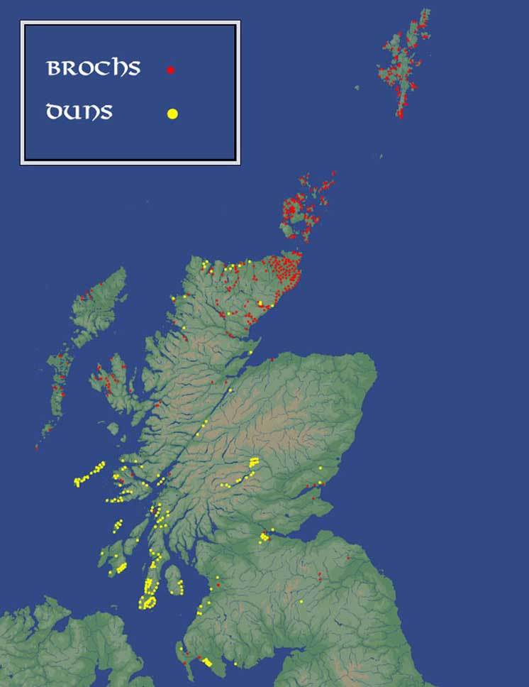
The great thing about sailing round Scotland, is that it's the easiest way to visit most of the brochs as well.

The Brochs of Scotland are stone ruins found throughout the highlands and islands of Scotland. At some point, someone, somewhere, declared them to be iron-age forts and as is the way of academia this is the default position that everyone repeats. They are also commonly referred to as defensive structures, and it easy to see why, yet no-one can explain who they would be defending themselves from as a great many of the locations are overseeing coastal locations and the then (supposed iron-age) threat would have been the Romans who were invading from the south and not by sea. Although it is accepted that Agricola, then Roman governor of the invaded Britain, sent a fleet to survey and map Scotland’s coast the Brochs are mostly small constructions more capable of sheltering extended families than whole communities fearful of invasion. Small isolated groups of people would not have been capable of constructing such fortifications in a short time scale, (an impending Roman attack, we must defend ourselves) as the necessities of life, just living, would get in the way of a protracted building schedule.

I remember reading many years ago, and am quoting vaguely from that hazy memory, that one of the dating methods in establishng the age of Brochs was from the refuse and remains found in and nearby the Brochs. It would certainly fit the pattern of dating often cited so I'll accept that memory as reasonable. The problem though is that within this memory there also lies the first I read of the Beaker people (aka the Grooved-ware people).

Their remains, or more specifically, their distinctive potteries, were often found scattered throughout Broch sites (I cannot verify this, it is but a memory which may be garbled). Accepted Archaeology lists the Beaker folk as being Bronze age, which is a lo-oooong 2500 years before the supposed date of the Brochs. One of the distinctive markings of the Beaker potteries was a lozenge shaped design.


Image
Boreades
 
Posts: 2084
Joined: 2:35 pm

Re: Megalithic shipping and trade routes

Postby hvered » 11:58 am

Cormorants are seen as navigational aids by Irish fishermen because a cormorant on its rock shows the wind direction and perhaps where it is likely to come from. That would surely be helpful to sailors approaching a landing place or crossing lochs and estuaries wouldn't it?

Maps show various 'Shag Rock' islets just off the English south coast so presumably these are, or were, cormorant drying rocks. I wonder if it's possible to train the birds to use this rock and not that rock though.
hvered
 
Posts: 855
Joined: 10:22 pm

PreviousNext

Return to Index

Who is online

Users browsing this forum: No registered users and 131 guests