Trade Secrets

Current topics

Re: Trade Secrets

Postby macausland » 3:32 pm

With all the talk about Burgh island and similarly named places I was interested when I came across Burrow beach in the Irish Republic.

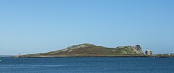
Very close to this beach is an island 'Ireland's Eye'. Apparently it was originally called 'Eria's island' but then renamed by the Norse when they invaded and 'Eria' became confused with 'Erin'.

It's a familiar looking island complete with monks, cormorants and sea stacks.

In the video the man giving the talk mentions that his house overlooks the bay and if anybody would want to put a finishing touch to it they would place an island in the same spot. He supports this with a description of the outline of the island and how it climbs up gradually from a low point at one end to the other.

http://doneganlandscaping.com/blog/2010 ... lands-eye/
macausland
 
Posts: 339
Joined: 3:17 pm

Re: Trade Secrets

Postby hvered » 4:57 pm

I looked at Ireland's Eye in connection with the route that goes via the Mull of Kintyre down to the Med; in the Irish Sea section it goes closer to Ireland than Wales, probably to avoid the Skerries and reefs off Anglesey

Image

but I hadn't known about Burrow Beach so definitely worth looking at again.

I wonder how common, or not, such features are and if they keep appearing simply because they're in an area that's being looked at more closely than elsewhere.
hvered
 
Posts: 855
Joined: 10:22 pm

Re: Trade Secrets

Postby macausland » 6:29 pm

http://www.youtube.com/watch?v=sPRvwhM2b7Q

Here's a video of Burrow Beach posted by the Irish Kite Surfers' Association.

There are a few close ups of the island in the background and lots of information regarding tides and wind directions as well as shots of the beach itself. Some satellite pictures to illustrate tides etc.
macausland
 
Posts: 339
Joined: 3:17 pm

Re: Trade Secrets

Postby hvered » 7:57 pm

Plenty of marram grass too. Interestingly, Howth Head peninsula which is connected to the mainland by a sandy tombolo was according to Wiki described as an island by the Greek geographer Ptolemy. He called it Edrou Heremos which suggests it was inhabited by a hermit perhaps tending a beacon; it is now the site of Baily lighthouse.
hvered
 
Posts: 855
Joined: 10:22 pm

Re: Trade Secrets

Postby macausland » 9:32 pm

I imagine that 'Edrou' is the same word as 'Eria' the old name for the island. Or possibly 'Heremos' was the base word, they both sound similar.

If so it says a lot for continuity across the ages regarding place names.

In the video they mention that the old church had a tall tower attached. Perhaps that was a lookout post?
macausland
 
Posts: 339
Joined: 3:17 pm

Re: Trade Secrets

Postby spiral » 10:18 am

Mick Harper wrote: the purpose of causeways and why they are put on tidal islands (and why tidal islands are constructed) is still a complete mystery. Your comments are all very well but surely everything you say could be conducted just as easily on an ordinary shore. Why bother with tidal islands and causeways? The tide, the stars etc are just the same.


Not so. Tides differ dramatically, the Mediterranean mariner was probably unaware/had no concept of tides at all. OK, I exaggerate a tad.... but you get my drift.
spiral
 
Posts: 228
Joined: 8:10 pm

Re: Trade Secrets

Postby hvered » 7:28 pm

I was intrigued to see that the north-east corner of Jersey has a headland called La Coupe. There's no dramatic causeway as at Little Sark but it has an interesting shape

Image

La Coupe is exactly north of Saint Malo's cathedral built on top of the earlier monks' church. It is dedicated to St Vincent who is about to be added to the list of 'Megalithic saints'. Coupe means cut in French but whether or not the cliffs have been cut or shaped the headland is at a very useful navigational location.

Saint Malo itself is a tidal island, accessible on foot at low tide via a causeway.

Image
hvered
 
Posts: 855
Joined: 10:22 pm

Re: Trade Secrets

Postby macausland » 9:03 pm

Coupe also means a bowl or goblet. Perhaps even a 'grail' or 'graal'?
macausland
 
Posts: 339
Joined: 3:17 pm

Re: Trade Secrets

Postby hvered » 8:02 am

macausland wrote:I imagine that 'Edrou' is the same word as 'Eria' the old name for the island. Or possibly 'Heremos' was the base word, they both sound similar.

If so it says a lot for continuity across the ages regarding place names.

Eria sounds very similar to l'Erée, the headland that overlooks the causeway connecting Lihou Island to Guernsey. I don't know what l'Erée means but it doesn't seem to have much to do with 'Eire'; rather weirdly 'arie' in Hebrew means lion and Lihou is pronounced 'leo'.

In the video they mention that the old church had a tall tower attached. Perhaps that was a lookout post?

The church at St Michel du Valle at the north-eastern point was built on top of a mound making it visible for miles across the marshes.

Lookouts don't need to be tall if they're on a high point, towers are intended to be seen. A book by Brian Fagan that I've just started describes how Danish churches are the only distinguishing sea-marks on that coastline.
hvered
 
Posts: 855
Joined: 10:22 pm

Re: Trade Secrets

Postby Mick Harper » 8:36 am

Extract Thirty

Jethou seems to represent a considerable capital investment but to what end? Its only obvious waymarking function is as a guide from Little Sark to Vale Island but since this is a journey in which all the islands are clearly intervisible this seems extravagant.

Image

A more likely possibility is that Jethou is the southern ‘pole’ in an interesting ‘prime meridian’. The only time that a Great Circle route coincides with a compass/chart route is when both are precisely oriented north-south. But more than that, north will always be the 'cardinal point' because it is the only direction that remains fixed to a single star, the pole star, whatever that star happens to be in the relevant era. It may then be taken as axiomatic that north-south will always be of great significance to ancient navigators.

But why choose Jethou as the southern ‘pole marker’? The most obvious reason is that, it just so happens, sailing due north from Jethou takes the mariner very conveniently through the inner islands, safely past the Casquets and on to the Britain. But is there any evidence that Jethou was used for this purpose? The evidence is circumstantial but hard to resist since the 'Jethou Meridian' on its precision passage northwards passes over not one but two of the most important Megalithic constructions on the adjacent part of the British mainland.

And just to make the point, one of them is a clone of Jethou! Same shape, same size, same apparent contruction technique:

Jethou, near Guernsey, Channel Islands

Image

Maiden Castle, north of Weymouth, Dorset

Image
Mick Harper
 
Posts: 910
Joined: 10:28 am

PreviousNext

Return to Index

Who is online

Users browsing this forum: No registered users and 244 guests