The Megalithic Portal has posted up some pretty pictures of Wolin, the location of the largest German-Scandinavian-cum-Viking re-enactment festival in the world. Possibly it was a centre of the Baltic amber trade?
Wolin has a strikingly Megalithic aspect. Aerial photos on the Wiki page show its position between the Baltic Sea and the Szczecinski lagoon aka Stettin or Oder lagoon (the northern end of the all-important Oder-Neisse Line)

Not much happened/is known about Wolin during the 8th to the 11th centuries even though that is generally reckoned to be 'the Viking Age'. Enough Stone Age archaeology seems to have survived but after that things are less clear: "indicate that", "abandoned", "approximately" come into play and the evidence somehow elides a 500-600 year gap.
The ford across the river Dzwina on which Wolin is located has been used as far back as the Stone age. Archaeological excavations of soil layers indicate that there was a settlement in the area during the Migration period, at the turn of the 5th and 6th centuries. The place was then abandoned for approximately one hundred years.
At the end of the 8th or the beginning of the 9th century the area was leveled and a new settlement constructed. The earliest evidence of fortifications dates to the first half of the 9th century. In the second half of the 9th century there was a central fortified area and two suburbs, to the north and south of the center. These became enclosed and fortified between the end of the 9th and the 10th centuries
All of a sudden Wolin becomes hugely important as a trading emporium
The period of greatest development during the medieval period occurred between the 9th and the 11th centuries. Around 896 AD a new port was constructed and the main part of the town acquired new, stronger fortifications, including a wooden palisade made of halved 50 centimeter wide tree trunks, a rampart and a retaining wall.
Archaeologists believe that in the Early Middle Ages Wolin was a great trade emporium, spreading along the shore for four kilometers and rivaling in importance Birka and Hedeby.
The source for Wolin's trading success is a medieval i.e. twelfth-century Latin document, the
Bavarian Geographer, discovered in 1772.
To the west of Wolin is a second island, the island of Usedom
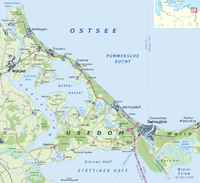
The island is separated from the neighbouring island of Wolin to the east by the Strait of Świna (German: Swine), which is the main route connecting Szczecin Bay with the Pomeranian Bay, a part of the Baltic Sea. The strait between the island and the mainland is called the Peenestrom; it is a downstream extension of the valley of the Peene river, which flows into the westernmost part of the Stettin Lagoon. The island is mostly flat, partly covered by marshes.
The history of Wolin's neighbouring island may be the clue to Wolin's prosperity
Settled since the Stone Age, the area was probably inhabited by Germanic Rugians, before the Polabian Slavs moved in during the fifth, sixth, and seventh centuries. Around the island, Wendish/Scandinavian trade centres such as Vineta/Jomsborg and Menzlin were established. In 1128 the Slavic Pomeranian Duke Wartislaw I was converted to Christianity through the efforts of Otto of Bamberg. In 1155 the Premonstratensians established a monastery in Grobe, generally known as Usedom Abbey, which in 1309 was moved to the village of Pudagla. In the meantime, a Cistercian nunnery was founded in Krummin and soon almost the whole island was in the possession of one or the other of the ecclesiastical orders. During the Reformation, ownership passed to the Slavic dukes of Pomerania, who took over the island.
I'd wondered if there could be a 'wool' connection but Wiki thinks the name Wolin means wetland 'in the old Slavic language'
The origins of the name are unknown, although it is likely of Slavic origin. In the old Slavic language the word wolyn meant a wetland. [citation needed]