Keeping your feet dry, 8,000BC

Current topics

Keeping your feet dry, 8,000BC

Postby Boreades » 3:57 pm

I don't suppose I'm the only TME contributer that have been enjoying a complete and utter Noah of a Christmas in Merry England 2013. The rain has been persisting down, and my hens are up to their feathered arses in the puddles. Taking our dogs for a walk has been a joyful exercise in finding which pairs of boots leak the least. But we've had it easy compared to some.

Naturally I wondered when else it has been so wet in years gone by. That let me by various steps to a gem buried in a booklet published by the British Geological Society called 'Britain beneath our feet'

They say:
"Flooding is the major and most frequent recurring natural disaster in Britain. " (No shit Sherlock!) "But it is not a new phenomenon and geological information shows where it has happened in recent geological past - in the last 10 000 years. BGS holds data that show where the floodplains occur - the alluvial deposits that compose clay , silt sand and gravel left behind in previous inundations"

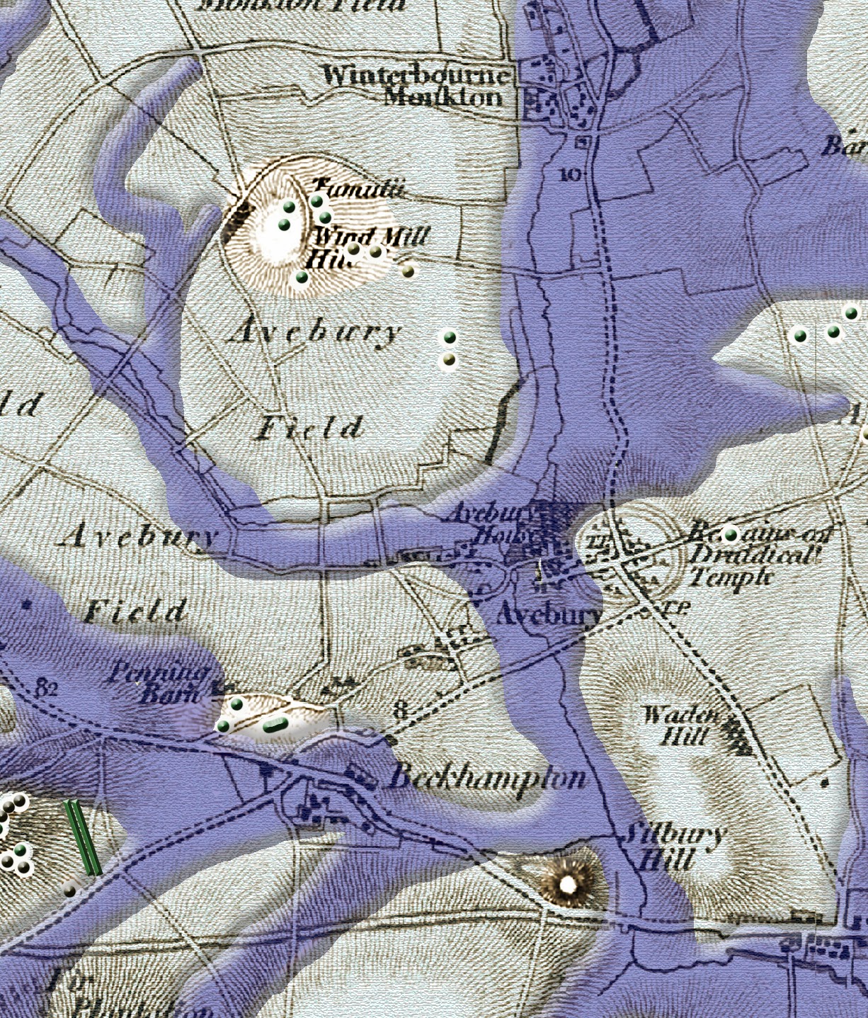
This is were it really starts to get interesting for TME. These were no ordinary floodplains - they were so extensive that Avebury and Stonehenge were harbours on rivers!

Image
BGS image for Southern England.

Immediately we can see that The Greater Ridgeway didn't just meander across southern England's chalk downs, it was in fact the only dry route between the west and east coasts of southern England.

Joy of joys, Robert John Langdon has taken the geological data and started producing detailed 25,000 scale maps of what that looked like.

User's Guide.
Image

Video introduction.
Boreades
 
Posts: 2096
Joined: 2:35 pm

Re: Keeping your feet dry, 8,000BC

Postby macausland » 6:03 pm

Boy, that's some find.

Why didn't anybody think about it before? It seems so obvious when you think about it. All that melting ice must have flooded the countryside. No doubt Stonehenge was simply sailed from Wales or wherever they got the stones from. No more need to chop trees down for rollers to bring them overland.

There's a video on youtube about underground London where they discuss Roman wharves which were built on the banks of the Thames. One problem was they collected silt which then changed the course of the river meaning that the Romans had to keep building further wharves to keep up with the changing river course.

I came across an American site which discusses the use of stone circles regarding star alignments etc. and they compare the design of Stonehenge with the design of Pawnee Star Lodges. Perhaps the Pawnee sailed up to Wiltshire and passed the idea on?

http://www.megaliths.net/

If all these Bury sites are indeed sites on the edge of navigable river systems this would link in the the number of Bury, Barrow, Barry names already discussed regarding coastal sites. In this case Bury becomes a generic name for a waterside building complex?
macausland
 
Posts: 339
Joined: 3:17 pm

Re: Keeping your feet dry, 8,000BC

Postby jon » 12:42 pm

Why didn't anybody think about it before? It seems so obvious when you think about it. All that melting ice must have flooded the countryside.


Whoa Guys. Don't get too excited about this. It looks almost identical to a flood map. You can get a flood map for your own area by going to the link below and then typing your postcode into the top right hand corner:

http://www.environment-agency.gov.uk/ho ... 37793.aspx

But look at the South of England on the same map: We know that the glaciers never got that far, so the flooding on the map could only be due to raised water levels. There's a flaw in the logic here: If the ice were still melting, the water levels would be lower, not higher.
jon
 
Posts: 108
Joined: 8:51 am

Re: Keeping your feet dry, 8,000BC

Postby macausland » 1:00 pm

'There's a flaw in the logic here: If the ice were still melting, the water levels would be lower, not higher.'

Perhaps the ground became saturated with the melt water?

With the warming of the atmosphere wouldn't there be a high rainfall as well as water freed from the ice?
macausland
 
Posts: 339
Joined: 3:17 pm

Re: Keeping your feet dry, 8,000BC

Postby jon » 1:15 pm

With the warming of the atmosphere wouldn't there be a high rainfall as well as water freed from the ice?


Yes: The polar axis at that point in time would have been nearer to 24 degrees rather than the 23.5 of today. This results in warmer summers and colder winters with probably higher rainfall.

However, the key thing is the coastal areas. The water level of the sea will not be raised by higher rainfall and stored ice: The water level of the sea will be lower. Some areas will be more prone to occasional flooding, but this is very different to a permanent shoreline.
jon
 
Posts: 108
Joined: 8:51 am

Re: Keeping your feet dry, 8,000BC

Postby Boreades » 1:02 pm

Yes. I'm not entirely convinced by Robert John Langdon' ideas (that these valleys had water all year round, for hundreds or thousands of years). But Bryn Walters (Director of the Association for Roman Archaeology) tells me that there is archeological evidence that rivers like the Kennet and Og were used by boats or barges.

Wasn't there some recent archeo work near Stonehenge that found something like a dock or landing stage on the river Avon?
Boreades
 
Posts: 2096
Joined: 2:35 pm

Re: Keeping your feet dry, 8,000BC

Postby jon » 1:24 pm

But Bryn Walters (Director of the Association for Roman Archaeology) tells me that there is archaeological evidence that rivers like the Kennet and Og were used by boats or barges.


Increased rainfall, so you would expect the rivers we see today to be carrying a higher volume of water. Makes a lot of sense.

Jon
jon
 
Posts: 108
Joined: 8:51 am

Re: Keeping your feet dry, 8,000BC

Postby Boreades » 1:53 pm

Here's the geological map, with the Greater Ridgeway and Pedlar's Way added.

Image
Boreades
 
Posts: 2096
Joined: 2:35 pm

Re: Keeping your feet dry, 8,000BC

Postby spiral » 6:08 pm

Interesting. But is the Pilgrims way blocked off?
spiral
 
Posts: 228
Joined: 8:10 pm

Re: Keeping your feet dry, 8,000BC

Postby Boreades » 6:39 pm

Just received a very nice email from the BGS

Thanks for your email. Sadly the Britain beneath our Feet publication is a number old years and is no longer current so has been removed from the website. However, the underlying data has since been updated and is still accessible. The dataset you refer to is known as ‘Geological Indicators of Flooding’. More information on it can be found at http://www.bgs.ac.uk/products/hydrogeol ... oding.html

The detailed GIS layer at 1:50 000 is available to licence, however we have lower resolution version of the dataset that is available to view online through our GeoIndex. To do this, open the onshore GeoIndex
http://mapapps2.bgs.ac.uk/geoindex/home.html
, click ‘Map Layers’, change the Map Theme to ‘Hazards’, and tick the ‘Geological Indicators of Flooding’ box.

You should then be able to zoom in, pan around and print/export your map.
Alternatively I can arrange a quote to licence the detailed data.
I hope that helps.
Kind regards.
Boreades
 
Posts: 2096
Joined: 2:35 pm

Next

Return to Index

Who is online

Users browsing this forum: Google [Bot] and 76 guests