Who Built The Stones?

Current topics

Re: Who Built The Stones?

Postby TisILeclerc » 2:15 pm

Govan means Smith

So perhaps he provided tools for whoever was carving the arches.

He was also pestered by pirates who were interested in a bell he rang. He could also ring the stones as well. Very gifted.

The gaelic for bell is clag or clog or other variants. Very close to the English 'clock'.

https://en.wikipedia.org/wiki/St_Govan

Govan is also associated with Gawain connected to Arthur the other miracle metal worker.
TisILeclerc
 
Posts: 790
Joined: 11:40 am

Re: Who Built The Stones?

Postby TisILeclerc » 8:11 am

Ancient sites have been found in Kazakhstan thanks to NASA and their photographs of that area.

Archaeologists appear to be rather perplexed as the nomadic hunter gatherers they assume lived nine thousand years ago would not be able to build such things. Perhaps there was a much more organised and older society?

But scientists have been surprised by the idea that a nomadic population would have stayed in one place for the time required to fell and lay timber for ramparts, and to dig out lake bed sediments to construct the huge mounds - originally six to 10 feet high, and now three feet high and nearly 40 feet across.

“The idea that foragers could amass the numbers of people necessary to undertake large-scale projects — like creating the Kazakhstan geoglyphs — has caused archaeologists to deeply rethink the nature and timing of sophisticated large-scale human organization as one that predates settled and civilized societies,” said Persis Clarkson, an archaeologist at the University of Winnipeg, who viewed some of Mr Dey’s images.


Well, they've got a bit of catching up to do.

Image

http://www.telegraph.co.uk/news/science ... ement.html
TisILeclerc
 
Posts: 790
Joined: 11:40 am

Re: Who Built The Stones?

Postby hvered » 6:30 pm

Uncannily like the Nazca lines. Thanks, TisI.
hvered
 
Posts: 856
Joined: 10:22 pm

Re: Who Built The Stones?

Postby Mick Harper » 11:23 am

Here's another telling quote from Celtic Saints of Wales by Elizabeth Rees.

Some hermits preferred to live on islands where they could pray without disturbance. A number of small monastic sites are on islets connected to the mainland only at low tide. This enabled monks to combine solitude with easy access to centres of population. A monk named Cwyfan who was said to be a disciple of St Beuno gave his name to the tiny church on Llangwyfan, a tidal island off the Anglesey coast north of Aberffraw.


As we have constantly pointed out a) tidal islands are rare in nature and b) monks seem to live on them unnaturally frequently. This situation is so 'common' that historians, and here Ms Rees just goes along with them, take it all for granted. Consider, for instance, the phrase "this enabled monks to combine solitude with easy access to centres of population". This theory is repeated over and over again in textbooks but is actually rather soppy. It would be equally correct to say that "centres of population had easy access to the monastery so there could be no question of solitude for the monks."

This is important because it would appear to be a fact that Celtic monks (or Megalithics as we would call them) actually create tidal islands -- that is the only explanation for their frequency -- which is extraordinarily expensive to do but we still have no idea why.
Mick Harper
 
Posts: 916
Joined: 10:28 am

Re: Who Built The Stones?

Postby TisILeclerc » 12:49 pm

Is there a standard size and shape for these tidal islands?

If so it may be possible to adopt an engineering or architectural approach to their analysis which could give some idea of their thought processes.

For example Iona and Lindisfarne which were connected in religious terms are roughly the same size, the same distance from the mainland, about a mile, and have similar sized populations.

https://en.wikipedia.org/wiki/Iona

https://en.wikipedia.org/wiki/Lindisfarne
TisILeclerc
 
Posts: 790
Joined: 11:40 am

Re: Who Built The Stones?

Postby Mick Harper » 3:37 pm

This is an excellent way of looking at these 'islands', Tis. Here's a quote from Ms Rees that might contribute to the debate

Over the centuries the surrounding land has been eroded creating an island which is now a rocky outcrop in Caernarvon Bay ... In 1802 John Skinner wrote ‘Llangwyfan Church is erected on a rocky peninsula jutting out into the sea and is an island at high water so that not infrequently the congregation were interrupted in their devotions by the rapid approach of the waves.’

The island is less than an acre ... connected to the mainland at low tide by a causeway that is two hundred metres long. The single-chambered church dates from the fourteenth century to the sixteenth century and contains some Norman stonewor
k.


I don't know whether Llangwyfan is a tidal island now (the definitive book on tidal islands No Boat Required only covers the British mainland, but here's some standard material (my underlinings which I'll comment on):

The most recognizable church on Anglesey, St. Cwyfan's, is popularly know as the Church in the Sea (or eglwys bach y mor in Welsh). Perched on a tiny island called Cribinau, encircled by a sea wall, this simple medieval church dates to the 12th century. It is thought to be dedicated to the Irish St. Kevin, who founded the monastery across the sea at Glendalough in Co Wicklow, Ireland.


In other words it is presumably the British end of an Irish trade route.

It may seem an odd and perilous place to build a church, but it originally stood at the end of a peninsula between two bays, Porth Cwyfan and Porth China, as shown on John Speed's map of Anglesey from 1636 (shown left).


As we have seen so often, for some reason 'Megalithic' churches are built in the most unlikely places if they were churches.

In the decades after this the sea slowly eroded the coast in the two bays enough that the peninsula was cut off, turning it into an island.


Well, maybe. But this emphasises the point I made in my Glastonbury lecture, that tidal islands don't last very long (if they are natural features).

A causeway was built to the island to allow parishioners to get to the island. (3) Its remains are visible in the picture below. However, even with the causeway, sometimes high tides prevented access. At those times services were held in a room in the nearby house, Plas Llangwyfan, which was specially consecrated for the purpose.


It seems to me baffling that people would go to the huge engineering trouble of building a causeway rather than just building a new church on the mainland.

The waves continued to eat away at the island until, in the late 19th century, some of the graves surrounding the church began to fall into the sea. At this time the church was also disused and roofless, having been replaced by a new church further inland. However, in 1893 local architect Harold Hughes, concerned for the fate of this evocative old church, raised money to save the it by constructing a seawall around the island and restoring the building


Quite so. And yet even now people still think it worth stumping up really considerable sums of money to save ... well, what exactly? The 1890's were not a time when conservation and heritage for their own sake were the rage they are now.

Although the church was initially built in the 12th century, only a small portion of the south wall dates from this period. Most of the walls were rebuilt during a 14th century reconstruction. In the early 16th century an aisle was added to the north side, accessed through an arcade of three arches, but it was demolished in the early 19th century as the cliff edge eroded ever closer. The infilled arches can now be seen in the outer wall, after the old cement mortar was removed during refurbishment in 2006. This refurbishment also involved limewashing the walls, making them very white, to the consternation of some locals who were used to the old grey appearance.


Presumably they used to be just this way when it was a navigational (or whatever) feature.
Mick Harper
 
Posts: 916
Joined: 10:28 am

Re: Who Built The Stones?

Postby TisILeclerc » 5:05 pm

Perhaps when they were first built they were not islands as such but ports built on the edge of the shore?

As the seas rose they became islands but because of their importance causeways were built linking them to the operations still going on at the land not flooded.
TisILeclerc
 
Posts: 790
Joined: 11:40 am

Re: Who Built The Stones?

Postby Boreades » 6:32 pm

As I've mentioned elsewhere, am I correct in thinking that Elizabeth Rees is a Roman Catholic nun? I wonder if that explains her (apparent) stance that there are no Christians in Britain worth mentioning before Roman Christians arrived? As a reflective note: I still have to make a conscious effort to rid myself of the assumption that our blessed Saints always behaved as saints. It clearly wasn't "peace and love, man" when the saints came marching in, smiting the pagans, or indulging in internecine warfare.

I don't know what's it's like for you guys, but the other mental block I keep stumbling over is the separation between Church and State. Doh!!! That's just what we're used to now. But for our "Celtic Saints", it was all one big International Royal Family business. If you weren't already a Prince or a King or a brother or a cousin of another Prince or King, you didn't get far as a saint. They didn't get where they are today by being commoners!
Boreades
 
Posts: 2091
Joined: 2:35 pm

Re: Who Built The Stones?

Postby TisILeclerc » 12:17 am

I don't know what's it's like for you guys, but the other mental block I keep stumbling over is the separation between Church and State. Doh!!! That's just what we're used to now. But for our "Celtic Saints", it was all one big International Royal Family business. If you weren't already a Prince or a King or a brother or a cousin of another Prince or King, you didn't get far as a saint. They didn't get where they are today by being commoners!


Or simple navigators judging by the family tree of Henry the Navigator whose ancestry leaps from Portugal to England, Scotland and of course la Belle France.

https://en.wikipedia.org/wiki/Henry_the_Navigator

Speaking of which, I was wondering if the tidal islands may have represented permanent markers on a shifting coast line.

If you are mapping the coast it's a bit annoying to see the sea coming in and going out just when you'd done all your calculations. Stick an island a mile or so off the coast and you not only have something that won't move but which may be visible to another one further along the coast.

Do this all around the coast and back to square one and you've built a framework from which you can venture into the interior to continue the map making.

A by product is a series of permanent way stations manned by a body of professionals to keep everything ship shape and Bristol fashion so to speak.

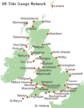
We do something similar to this today, or at least we did until a few years ago, with the tide gauges around the coast. They all referred eventually to Newlyn and were essential in checking heights above sea level from one end of Britain to the other.

Image

http://www.ntslf.org/data/uk-network-real-time

http://www.ntslf.org/tgi/newlyn-tidal-observatory
TisILeclerc
 
Posts: 790
Joined: 11:40 am

Re: Who Built The Stones?

Postby Boreades » 1:46 am

TisILeclerc wrote:Or simple navigators judging by the family tree of Henry the Navigator whose ancestry leaps from Portugal to England, Scotland and of course la Belle France.


I've always felt there's more to Trinity House than meets the eye. My nose tells me it's more ancient than its own legend would have us believe.
Boreades
 
Posts: 2091
Joined: 2:35 pm

PreviousNext

Return to Index

Who is online

Users browsing this forum: No registered users and 5 guests