Click the above logo to return to the main site
Click the above logo to return to the main site
![]() by Mick Harper » 6:20 am
by Mick Harper » 6:20 am
![]() by Boreades » 7:31 pm
by Boreades » 7:31 pm
![]() by Boreades » 3:31 pm
by Boreades » 3:31 pm
The discovery of a cursus monument site at Tormore on the Isle of Arran, which is more than a kilometre long, is helping to reshape Neolithic history in Scotland with such landmarks usually associated with the east coast.
Cursus monuments were often defined by long lines of timber posts, forming a long rectangle, and were amongst the most spectacular features in the Neolithic landscape. The posts may have served as a procession route, perhaps to honour the dead.
"I think if you asked the survey team what they thought they were most likely to find on Arran, I would bet you no one would say a Neolithic cursus monument
“There is no other on Arran, its unique on the island, there is one more in Kilmartin Glen and that is pretty much it for the western seaboard.
“What this example at Tormore tells is there are probably actually many more on them but because they were built from timber, you are not likely to see them in the unimproved peat landscape of the west coast
![]() by Mick Harper » 5:54 pm
by Mick Harper » 5:54 pm
![]() by Boreades » 12:18 pm
by Boreades » 12:18 pm
Six stone circles are visible on the moor immediately east of the derelict Moss Farm.[1] Some circles are formed of granite boulders, while others are built of tall red sandstone pillars. The moor is covered with other prehistoric remains, including standing stones, burial cairns and cists. The stone circles are positioned over previous timber circles. A radiocarbon date of 2030 ± 180 BCE has been found for the timber circle at Machrie Moor . Several hut circles can also be seen as low rings of turf-covered stone.
![]() by Boreades » 12:51 pm
by Boreades » 12:51 pm
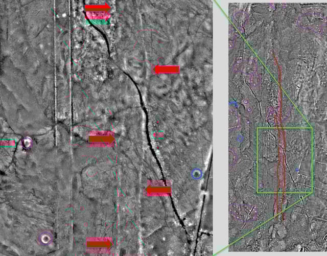
Mick Harper wrote:The theory put forward in Megalithic Empire is that cursuses are designed to intercept travellers who have missed their mark, returning them safely to their immediate destination. I couldn't imagine that the Isle of Arran would be large enough to require such (is it?). .
![]() by Boreades » 7:15 pm
by Boreades » 7:15 pm
Orkney 10,000 years ago was a very different place. The islands comprised a single land mass and many of the lands settled by Orkney’s early inhabitants now lie underwater
On the west coast of Arran, King’s Cave is where Sir Walter Scott said the 14th-century King Robert the Bruce encountered the struggling spider while he was defeated and on the run. It was that spider’s determination to spin its web that inspired Bruce to return to the mainland and defeat the English army.

![]() by PeterC » 10:11 am
by PeterC » 10:11 am
![]() by Mick Harper » 10:51 am
by Mick Harper » 10:51 am
I continued Mick’s new Michael line, from the direction of mont st.michel to burgh(Michael) island until it joined the Michael line proper. As I predicted they intersect at St Michaels, Brentor (formerly beacon tor). This line nicely hugs the edge of Dartmoor meaning that Ingot movers emerging from the Tamar Valley or from Exmoor could follow the Michael line to brentor and then follow the ‘new’ Michael line to burgh island without dealing with too much Dartmoor or winding up in Plymouth (something people desperately avoid still today).
My local church Walkhampton sits a top a promontory on the edge of the moor with a clear line of sight to Brentor with a few straight roads, fords and crossroads inbetween. Walkhampton Church is supposedly build on a megalithic site; no remains are obvious other than some massive granite gate posts casually reused in the local fields. However, the church does have a couple of other megalithic features - it sits on an almost unrecognisable crossroads made of mainly ancient drove ways and footpaths, the church apparently (according to Wikipedia, looking for confirmation) was dedicated to St Dionysius, the church house, apparently the old vicarage, has been used as an inn and finally, most damning of all, the church’s alignment is not east/west, but northeast/southwest and is supposedly the alignment of the previous structure. It has been suggested that this refers to midsummer sunrise, which is in fact much further north that the church points, but I feel like the alignment is at a right angle to the ley line it respects.
The line can be traced onwards to Yennadon Down which, although is historically featureless, today has a stand of tress that is visible for miles.
Just down hill is a ford (Meavy) which is surrounded by ancient oaks, unusual for an area that was pretty much treeless only 150 years ago (the village of Meavy also contains an ancient ‘Royal Oak’ and a pub bearing the same name).
The line seems to continue towards the dewerstone (Devon’s only ‘enclosed’ tor) and then on to boringdon camp, Iron Age site.
Get on Google Earth and see if you agree or not
![]() by PeterC » 1:19 pm
by PeterC » 1:19 pm
Users browsing this forum: Bing [Bot] and 3 guests