Megalithic shipping and trade routes

Current topics

Re: Megalithic shipping and trade routes

Postby spiral » 7:29 am

spiral wrote:The control part of a ship is after all the "Bridge". It's a survival of the time boats were designed to act as bridges. (?)


Ship is a variant of shape. You originally used your ship to shape......

Mick wrote:After all, it's a tricky technical matter both floating something out and letting it sink.


Surely floating and sinking is a lot easier than sailing. That must have happened later.

No, I aint backing off on this. Ships were originally designed to be sunk.
spiral
 
Posts: 228
Joined: 8:10 pm

Re: Megalithic shipping and trade routes

Postby spiral » 7:42 am

This is why your ancients could eventually transport large megaliths. They were already used to moving and sinking stones short distances to shape the landscape, to create causeways etc, they then evolved this skill to travel further.

Orthodoxy has this perception that ships came first and then they decided to move the stones, using ships,which is of course a mad thing to do.

No your ancients were already shaping/shipping the landscape by floating and sinking, they then very slowly incrementally refined this skill into sailing with large stones on board.
spiral
 
Posts: 228
Joined: 8:10 pm

Re: Megalithic shipping and trade routes

Postby Boreades » 11:39 pm

If we suppose that marine engineering skills came before civil engineering skills, then yes.

But why not both?
Boreades
 
Posts: 2113
Joined: 2:35 pm

Re: Megalithic shipping and trade routes

Postby Mick Harper » 12:15 am

I think this has been mentioned before but it's worth trotting out again. It's a very rum road in Whistable. We really ought to be solving it.

http://www.megalithic.co.uk/modules.php ... =4&start=0
Mick Harper
 
Posts: 929
Joined: 10:28 am

Re: Megalithic shipping and trade routes

Postby Boreades » 12:26 am

The Street in Whitstable is indeed a curious thing. It seems to be aligned north-south with St Augustine's Abbey in Canterbury.

Which reminds me, while I've been poking about for fractional latitudes, I did wonder about the longitude of some ancient sites in Egypt. I wondered where you would get to if you travelled exactly 30 degrees west in Britain. It's Canterbury.
Boreades
 
Posts: 2113
Joined: 2:35 pm

Re: Megalithic shipping and trade routes

Postby Mick Harper » 8:35 am

Since the Street is presumptively pre-historic, this would mean that St Augustine's Church (or at least its site) was presumptively pre-historic. Which means St Augustine himself must be doubtful as an actual historical figure. Tell Ishmael.

Good spot re Egypt. But how close is close?
Mick Harper
 
Posts: 929
Joined: 10:28 am

Re: Megalithic shipping and trade routes

Postby TisILeclerc » 12:48 pm

'Which reminds me, while I've been poking about for fractional latitudes, I did wonder about the longitude of some ancient sites in Egypt. I wondered where you would get to if you travelled exactly 30 degrees west in Britain. It's Canterbury.'

Borry old chum the link that Mr Harper gives to the article on Street also leads to the author of that article and he has done a series of articles on the idea that the English landscape is based on the zodiac but extends according to position of the sun etc to other parts of the world.

He ties this in with an explanation of place names to support his theory. Interestingly he uses the English placenames to interpret these prehistoric landscape markers.

Here's one he did earlier covering Halloween. Gets a bit naughty at times. Shades of Carry On Up The Solstice methinks.

http://fen-lander.hubpages.com/hub/The- ... -West-Kent
TisILeclerc
 
Posts: 790
Joined: 11:40 am

Re: Megalithic shipping and trade routes

Postby hvered » 2:52 pm

Ta very much, TisI. The link you posted throws up several 'classic' alignments. How accurate they are is another matter but, giving the author the benefit of the doubt, it shows the autumn equinox follows the line of the Isle of Thanet's north coast through Whitstable and, more significantly, as Ollie has already noted, Herne Bay (named for Herne the hunter, or Hermes?), to Margate, the 'sea-gate'.

Canterbury is one of the waymarks on the east-west route from Margate, originally called St John's (after the Baptist), ending at Worlebury Hill above Weston-super-Mare (also with a John the Baptist church) on the north Somerset coast.

Image

The winter solstice line he shows crossing the Isle of Wight which is even more interesting as one or two people think the island, noticeably lozenge-shaped, isn't where it is by chance.
hvered
 
Posts: 856
Joined: 10:22 pm

Re: Megalithic shipping and trade routes

Postby hvered » 9:57 am

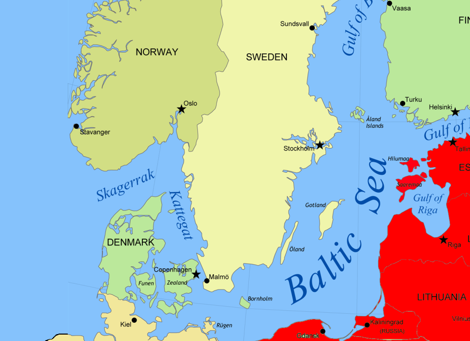
Just came across an even more lozenge-shaped island called Bornholm between the Kattegat, to be navigated with circumspection, and the Baltic Sea

Image

which according to legend is the birthplace of the Burgundians, though Born presumably refers to fresh-water springs which the island has in plenty, as well as Denmark's "only tarn" or mountain lake, the Hammersø.

Bornholm is of Special Megalithic Interest as the site of a Neolithic 'sun temple' ("Bornholm's Stonehenge"), 55° N, 15° E, though it sounds more like a beacon hill from the article in Wiki:

From the clay pieces, burnt flint and burnt bones found on the site, it has been suggested that the circles may have served as a sun temple. They apparently supported a clay-covered platform, accessed by a flight of steps, on which experts believe fires could have been lit, possibly for sacrifices. Clay disks with ancient sun symbols have also been found, ritually buried under the poles. It appears as if the wooden circles were constructed over three separate periods


This island must have been of strategic importance as northern Europe's largest medieval fortress, the Hammerhus, is on the Hammeren, a granite promontory that marks Bornholm's northernmost point.

The easternmost point is Svaneke ('Swan-wick') which has a distinctly sinister-looking swan or goose holding (swallowing?) what seems to be a ring as its guardian angel

Image
hvered
 
Posts: 856
Joined: 10:22 pm

Re: Megalithic shipping and trade routes

Postby Boreades » 8:27 pm

Ma wee cousin MacBoreades (much distracted by local events) has only just sent news of great discoveries on Orkney.

The archaeological site, known as the Ness of Brodgar, covers an area of over 6 acres and consists of the remains of housing, remnants of slate roofs, paved walkways, coloured facades, decorated stone slabs, a massive stone wall with foundations, and a large building described as a Neolithic ‘cathedra’ or ‘palace’, inhabited from at least 3,500 BC to the close of the Neolithic period more than a millennium and a half later.

“Their workmanship was impeccable. The imposing walls they built would have done credit to the Roman centurions who, some 30 centuries later, would erect Hadrian’s Wall in another part of Britain. Cloistered within those walls were dozens of buildings, among them one of the largest roofed structures built in prehistoric northern Europe. It was more than 80ft long and 60ft wide, with walls 13ft thick,” said Roff Smith, author of an article on the Ness of Brodgar to be released in the August edition of National Geographic.

Archaeologist Nick Card, excavation director with the Archaeology Institute at the University of the Highlands and Islands, says the recent discovery of these stunning ruins is turning British prehistory on its head.

“This is almost on the scale of some of the great classical sites in the Mediterranean, like the Acropolis in Greece, except these structures are 2,500 years older. Like the Acropolis, this was built to dominate the landscape—to impress, awe, inspire, perhaps even intimidate anyone who saw it. The people who built this thing had big ideas. They were out to make a statement.”

Also found among the ruins were prized trade goods such as volcanic glass from as far afield as the Isle of Arran in western Scotland, and high-quality flints from across the archipelago and beyond. These artifacts suggest that Orkney was on an established trade route and that the temple complex on the Ness may have been a site of pilgrimage.

More intriguing than the items traders and pilgrims brought to the site, say archaeologists, is what they took away: ideas and inspiration. Distinctive colored pottery sherds found at the Ness and elsewhere, for example, suggest that the trademark style of grooved pottery that became almost universal throughout Neolithic Britain had its origin in Orkney. It may well be that rich and sophisticated Orcadians were setting the fashion agendas of the day.


See
http://ngm.nationalgeographic.com/2014/ ... smith-text
and
http://www.scotsman.com/lifestyle/herit ... -1-3490079
and
http://www.ancient-origins.net/news-his ... old-temple
Boreades
 
Posts: 2113
Joined: 2:35 pm

PreviousNext

Return to Index

Who is online

Users browsing this forum: No registered users and 33 guests