Megalithic shipping and trade routes

Current topics

Re: Megalithic shipping and trade routes

Postby Boreades » 1:59 am

The venue's fine, Edinburgh. But, tut, shame about the date (11th January 2016).

M'Lady Boreades and 'er 'umble hautomobile chaf are off to Edinburgh before then. M'Lady has heard something about a famous establishment/purveyor of uisce beatha in that fair city. I dunno where she gets these ideas.

I may visit ma wee cousin MacBoreades and brush-up my tartan.

Any suggestions (of a TME-nature) on what to do in Edinburgh for three days?
Boreades
 
Posts: 2113
Joined: 2:35 pm

Re: Megalithic shipping and trade routes

Postby TisILeclerc » 10:05 am

You could walk up Calton Hill at the end of Princes Street and look at the ley lines. Or streets if you prefer.

Then a quick trip to Mary King's Close. It may look tacky on the website but it is fascinating. Underneath the City Chambers on the High Street or Royal Mile if you prefer, it is the old Edinburgh that was there before the plague. They knocked the top buildings off and used the buildings going down the slope as foundations for the new buildings they put up. Very canny people in Edinburgh.

http://www.realmarykingsclose.com/plan- ... rices.aspx

If you fancy a jaunt up Arthur's Seat you could look for the sword in the stone. And Salisbury Crags is a fine vantage point. Take your Sherpa and a stout pair of boots. And keep the musket loaded.

http://www.royal-mile.com/interest/salisbury_crags.html

A quick trip to Tollcross and Bennet's Bar with its food and wonderful collection of single malts. See if they've still got the ones on wee shelves at the back of the bar. The labels are white and either hand written or typed. In 1990 they charged £4 a nip. But well worth it. You can discuss megaliths with the staff and customers who will be fascinated.

https://www.facebook.com/Bennets-Bar-105721362827905/

Then there's Sandy Bells just by Greyfriars Bobby and the kirkyard where the poor mutt broke the hearts of the stone hearted citizens of that fair city. Or not. It used to be a gathering place for all the local fiddlers.

http://www.sandybellsedinburgh.co.uk/sessions.html

Round the corner is Chambers Street and the National Museum.

http://www.nms.ac.uk/

Oh, and there's a castle at the top of the high street which fires a big gun at one o'clock every day. When it goes off you'll notice people in the streets around checking their watches. Have your camera ready.

The Botanical Gardens are quite nice.

http://www.rbge.org.uk/

St Margaret's Well? Which was moved to its present location in the nineteenth century.

http://www.megalithic.co.uk/article.php?sid=8327

Other than that I haven't a clue. Although they do keep finding Roman lions and other things.
TisILeclerc
 
Posts: 790
Joined: 11:40 am

Re: Megalithic shipping and trade routes

Postby Boreades » 12:30 am

Merci, mon ami.
Boreades
 
Posts: 2113
Joined: 2:35 pm

Re: Megalithic shipping and trade routes

Postby TisILeclerc » 10:08 am

de rien mon brave
TisILeclerc
 
Posts: 790
Joined: 11:40 am

Re: Megalithic shipping and trade routes

Postby Boreades » 12:34 am

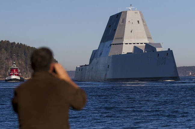
Captain James A. Kirk has just taken command of the USS Zumwalt. Yes, the new Captain really is called that. Sorry, not quite James T Kirk, but close enough.

The USS Zumwalt looks like one huge megalith of a ship. It's the US Navy's largest destroyer.

Image

It's a ship, but not as we know it, Jim!
Boreades
 
Posts: 2113
Joined: 2:35 pm

Re: Megalithic shipping and trade routes

Postby Mick Harper » 2:15 am

I just read that people used to be able to cross over to Anglesey at low tide. In other words Anglesey used to be a tidal island. Perhaps the largest in the world at the time -- other offers for the Guiness Book of Megalithic Records welcome. If you look at a map of the Menai Straits it's obviously artificial -- as I believe I've mentioned before.
Mick Harper
 
Posts: 929
Joined: 10:28 am

Re: Megalithic shipping and trade routes

Postby hvered » 8:32 am

The south-westernmost point of Anglesey, Abermenai, marks the western point of the straits.

Abermenai ferry was made Crown property, initially granted to Edward I's wife, Eleanor of Castille, clearly a well-used crossing until the bridge and railway were built.

Image

At low tide people were able to cross the mud and sand flats; from the map there appears to be a causeway of sorts. Hard to say whether man-made.

Image


On the other side of Britain, the south-east corner, is the Isle of Thanet which was also a tidal causewayed island, the most easterly point of Kent separated from the mainland until 1672 by a narrow estuary or channel, the Wantsum Channel, passable in only two places -- it may have of strategic significance or, more worryingly, the weak link but either way keeping the channel open wasn't apparently important. Interestingly, the 1953 flood damage in Ramsgate and the north coast of Thanet was reportedly limited by the amount of sand, creating a large beach held in place by wartime coastal defences (the shallower the sea, the less storm damage). Another large former tidal causewayed-island we've looked at is of course Vale, on Guernsey.

It's not altogether clear how easy or difficult it is to construct tidal causewayed islands but without a historical record they're not easy to spot apart from places that have retained 'Isle' or 'Island of', or -(s)ey. Unless you know what to look for, and are specifically looking. It may turn out they were two a penny.
hvered
 
Posts: 856
Joined: 10:22 pm

Re: Megalithic shipping and trade routes

Postby Boreades » 5:29 pm

TisILeclerc wrote: You could walk up Calton Hill at the end of Princes Street and look at the ley lines. (etc)...


We looked at them. They looked like tram lines. We followed them to St.Andrews Square, then diverted ourselves to George Street and supped in the Hard Rock Cafe. I'd like to claim that Hard Rock had megalithic meaning, but...

M'Lady sniffed suspiciously at the vendors of Genuine Highland Titles (and other tawdry tourist tat) on the Royal Mile, and poo-poo'd the offer of Earl of Cawdor. "Sounds too much like Mordor". Too Campbell as well, like the shortbreads on special offer (BOGOF). She didn't like the price of the trews either, let alone the full regalia. There aren't enough Burns Night in the year to make it cost-effective, and Clan Boreades gatherings in the Wiltshire area are rare events indeed. She didn't like Greyfriars Bobby, far too soppy & sentimental, and she's wondering whether there was more than one wee dug that had the job.

At the National Museum, the guide-person who guided us round a tour of Highland History was perhaps short of Highland material. Lots of the tour time was spent telling us about the likes of James IV (not a Highlander), the Lewis Chessmen (coincidentally, replicas available in the museum shops), Burke and Hare (not even Scottish), and the Arthur's Seat coffins (thankfully, no replicas in the museum shop).

M'Lady also tutted at the damp and peeling menus on display at the The Elephant House, famed as the birthplace of Harry Potter (volume one) by JK Rowling. So that location has lost a chance of greater fame as a birthplace of one of the Boreades' Volumes.

Apart from all that, we had a very nice time, and we enjoyed Edinburgh, despite the drecht weather!

Inchkeith, visible from Edinburgh, has potential as a megalithic island, despite the Rough Wooing.

https://en.wikipedia.org/wiki/Inchkeith
Boreades
 
Posts: 2113
Joined: 2:35 pm

Re: Megalithic shipping and trade routes

Postby Boreades » 2:54 am

Inchkeith, a different kind of Hard Rock, with strangely "the lowest average rainfall in Scotland at 550 millimetres (21.7 in) annually". and its own supply of coal.

Mentioned in passing in the 9th century Sanas Cormaic (good forgery if you can make it).

But we could look to it as a East Coast Scottish "Bear Island"

In 1548, it curiously involved a US Presidential namesake ( Edward Fiennes de Clinton ). You can trace the rest.
Boreades
 
Posts: 2113
Joined: 2:35 pm

Re: Megalithic shipping and trade routes

Postby TisILeclerc » 10:26 am

With your mention of megalithic islands in the Firth of Forth I was wondering what Forth itself might mean.

Is it a variation on the word Firth? Further inland at Stirling we are told that it is called Uisge For or Abhainn Dhubh. We are told that that means black river although they don't really define 'For'.

The River Forth (Gaelic: Uisge For or Abhainn Dhubh, meaning "black river"), 47 km (29 miles) long, is the major river draining the eastern part of the central belt of Scotland.


http://my.stirling.gov.uk/services/comm ... iver-forth

I wonder whether it has a connection with the Welsh fford meaning road? In which case does the road refer to the river as an ancient transport highway? If that were the case could Inchkeith be a customs' depot checking vessels going out and in?

An American dictionary gives the helpful information that Scotland is famous for bagpipes, plaids and kilts. Nothing else so maybe they were exporting these goodies way back when?

Scotland (one of the four countries that make up the United Kingdom of Great Britain and Northern Ireland; located on the northern part of the island of Great Britain; famous for bagpipes and plaids and kilts)


http://www.audioenglish.org/dictionary/ ... _forth.htm

By the way MacBorry did you not visit Mary King's Close or Bennet's Bar? Tut, tut. You missed a treat.
TisILeclerc
 
Posts: 790
Joined: 11:40 am

PreviousNext

Return to Index

Who is online

Users browsing this forum: No registered users and 34 guests