Megalithic shipping and trade routes

Current topics

Re: Megalithic shipping and trade routes

Postby TisILeclerc » 3:07 pm

Just lost a comment. If anyone sees it could you send it back please.

Meanwhile I'll try again.

Kintyre means Land's End. We have a Land's End, France and Spain have Finistere of some sort and there's presumably Pentland to add to the list.

Not every edge of the land is called Land's End. So why are these places given this name?

Is it something to do with specific location apart from the obvious one?
TisILeclerc
 
Posts: 790
Joined: 11:40 am

Re: Megalithic shipping and trade routes

Postby Boreades » 3:11 pm

Dál Riata deserves more of our attention.

Among the royal centres in Dál Riata, Dunadd appears to have been the most important. It has been partly excavated, and weapons, quern-stones and many moulds for the manufacture of jewellery were found in addition to fortifications. Other high-status material included glassware and wine amphorae from Gaul, and in larger quantities than found elsewhere in Britain and Ireland.


https://en.wikipedia.org/wiki/D%C3%A1l_Riata

Gaul and Britanny must have been busy shipping all this stuff. Like the voles to Orkney.
Busy shipping means busy ports. Like this place.

What did they get in return?
Whisky? Venison? Scottish oats? Haggis?

Edit: Leather as well. A much-underated trading commodity.
Last edited by Boreades on 3:46 pm, edited 1 time in total.
Boreades
 
Posts: 2113
Joined: 2:35 pm

Re: Megalithic shipping and trade routes

Postby Boreades » 3:27 pm

hvered wrote:Crinan came up when we were tracking the 'Scottish meridian' route.

Image


Dunadd should go on that map, as the strategically-positioned place that could monitor both the "outer" harbours around Crinlan and the "inner" harbour at Lochgilphead. It being half-way in between the two places.
Boreades
 
Posts: 2113
Joined: 2:35 pm

Re: Megalithic shipping and trade routes

Postby TisILeclerc » 5:14 pm

It's a perfect place strategically for a capital of sorts.

It's sheltered. Go west and you are out into the Atlantic. Skye has a bit of protection on the east but once you go west and out to the Outer Hebrides there is very little protection apart from local harbours.

It's also close to other centres of population as well as Ulster so very convenient for contacts.

Anyone attacking from sea would presumably be noticed long before they got to where they wanted to be.
TisILeclerc
 
Posts: 790
Joined: 11:40 am

Re: Megalithic shipping and trade routes

Postby Boreades » 10:28 pm

TisILeclerc wrote: Also there are the two Kilmartin and Kilmichael locations to take notice of. No sooner do you get settled down to a bit of piracy and metalworking than the Sally Army comes around banging their tambourines demanding tribute.


Kilmichael = Kilmichael Glassary?

What does Glassary mean?

Kilmichael Glassary appears to have a very good set of Cup & Ring marks.

Image

Bronze Age cup and ring carvings on a natural rock outcrop, near the school in Kilmichael Glassary village.
There are over 150 carvings on several exposed rock faces and nearby boulders, probably carved about 3000 BC. One rock with a well-preserved set of carvings has been fenced off. This is a sloping rock, but what is really striking is how deep the cup marks are compared to other rock art in the area.


http://www.britainexpress.com/attractio ... ction=1019

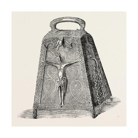
And what is this Tor A'bhlarain-bell Shrine in Kilmichael Glassary?

Image

http://archaeologydataservice.ac.uk/arc ... 2_0244.pdf
Boreades
 
Posts: 2113
Joined: 2:35 pm

Re: Megalithic shipping and trade routes

Postby TisILeclerc » 11:26 am

Crinan appears in a report by David Jones on the Edinburgh Geological Society's website. Along with many other places to do with mining of various sorts.

In around 1840, the Marquess of Breadalbane is recorded as having 'caused the copper mine at Tom na Dashan to be opened'. However, if we look at maps of the area made prior to 1840, these show, not very far to the west, the Allt a' Mheinn: the 'burn of the mine or ore'. Did the Marquess discover the source of ore as is claimed or was he perhaps simply re-opening a source previously worked?

There are, in fact, a large number of meinn-associated names across Scotland from Crinan and Loch Fyne to Lairg and Loch Fleet. The challenge is to relate them to the information given in the Geochemical Atlas for the areas.

To return to Tom na Dashan, if the name were a corruption of Tom na Dathan, the translation would be 'stained hillock', which would figure because the adit is still open and has blue-green copper compounds showing around its mouth. To the southwest of Tom na Dashan is a hill now shown on O.S. maps as Creag Uchdag but on earlier maps it is Creag Uigeach: 'the crag abounding with precious stones'. The geological map shows both copper an lead sources nearby. The eastern spur of this hill is separately named as Toll na Poite: 'the hole of the pot', and aerial photograph interpretation suggests that bell-pit working may have gone on there at some time.

To the east, the Urlar Burn flows down into the Tay past the farm of the same name. Urlar is normally translated as 'lowest part' and, incidentally, is the name given to the underlying or main theme in pibroch pipe music. But it can also be translated as 'a layer or vein as in a mine'. Two copper sources are shown on a geological survey map beside the Urlar Burn.

The name of Ardtalnaig has changed over a considerable number of years. It appears as Ardintollanie (1640), Ardtollony (1564) and Ardentollenie (1536). In the light of lead and zinc ore sources being shown within 300 metres on the geological map the cape (ard) of the little pits (tollan) looks like an indicator of early mining.

Incidentally, it is recorded that in 1342, Ardtalnaig had a Toiseachdeor, who was an important officer of the law in Celtic times. His rôle was probably that of a coroner and it may be asked whether he was needed in such a small place to investigate suspicious deaths from lead poisoning?

Over the hills to the south lies Glen Quaich. Cuach is the Gaelic for a hollow (the same word is used as a drinking vessel). But its meaning can also include mining pot holes, so it is no surprise that the Royal Commission Ancient and Historic Monuments' map of the area shows an old mine spoil tip beside the River Quaich. One of the burns that runs into the River Quaich is the Allt Salach, which translates as 'polluted burn'. The word salach also occurs in a number of other places in Scotland where early mining could have taken place. It is possibly an indicator of the washing of the ore in the burn nearest to the mine.


http://www.edinburghgeolsoc.org/edingeo ... 8_09a.html

It would appear that Cornwall and Wales were not the only mining areas. It was going on all over the place.

As for the cup and ring marks at Kilmichael Glassery and elsewhere there are old tales of them being for the 'fairies'. Milk and other stuff was poured into the holes for the fairies to help themselves. This would no doubt put them into a good mood.

But could it be that something else was poured into the holes. Like lead for example. This would produced small ingots of manageable proportions.

As for Glassery could that be related to glass? Glasair is the gaelic for glazier unsurprisingly so perhaps they were making glass in the area?
TisILeclerc
 
Posts: 790
Joined: 11:40 am

Re: Megalithic shipping and trade routes

Postby Boreades » 7:30 pm

Re Tomnadashan, it seems it was more than one person's Holy Grail:

Not only:

It was mined in the last century by the John Campbell, 2nd Marquis of Breadalbane. He spent a lot of his time and money on the search for a fabulous mineral wealth in the Scottish highlands. Unfortunately he never found it. Tomnadashan was the centre of his obsession.


Image

But also:

It is the locality, where the wild rabbit lived in Monty Python and the Holy Grail. Thanks to Monty Python, the rabbit is now dead, killed by the Holy Grenade of Antioch...
Boreades
 
Posts: 2113
Joined: 2:35 pm

Re: Megalithic shipping and trade routes

Postby Boreades » 9:14 pm

TisILeclerc wrote:Crinan appears in a report by David Jones on the Edinburgh Geological Society's website. Along with many other places to do with mining of various sorts.

It would appear that Cornwall and Wales were not the only mining areas. It was going on all over the place.


A comprehensive listing is here;
http://www.sat.dundee.ac.uk/~arb/scotla ... iblio.html

The first thing that caught my eye was the mention of the 4 degrees West of longitude meridian.

Adamson, G F S [1st ed 1988, 2nd ed 1991] At the end of the rainbow / The occurrence of gold in Scotland. 101 pp, SB. Beaconsfield, Goldspear (UK) Ltd. Lists all the sites for alluvial gold in Scotland – I guess about a hundred. Most appear on the fourth parallel.

Callender, R M 1990 Gold in Britain 64 pp illus. Covers, Scotland, Wales, Devon and Cornwall etc. Interesting theory - all gold is found on the 4o West of longitude meridian. [p xiii]. pub Goldspear (UK) Ltd, Box 203, Beaconsfield, Buckinghamshire HP9 2TQ


Does that match any of our TME meridians?

Lots of lead and copper mines, even out on the western islands. e.g. on Islay

Mulreesh Mine : http://www.streetmap.co.uk/map.srf?x=14 ... hp=ids.srf
South Ardachie Mine : http://www.streetmap.co.uk/map.srf?x=13 ... hp=ids.srf

Callander, [=Callender] R M 1985 reprint The Ancient Lead Mining Industry of Islay. No 6 in a series [pub] Museum of Islay Life. In 1975 Dr Callender was awarded a Kodak Bursary so that a “comprehensive documentation could be made of the ancient lead mining industry in Scotland”.


Then we get onto the exotic metals.

Alva Silver Glen, Alva [NE of Stirling], Clackmannanshire

First worked in 1715, the Alva Silver Mine is the richest deposit of native silver ever found in Great Britain. The silver yield of the Alva mines two centuries ago was startling. The Silver Glen between Middle and Wood hills made £4,000 a week for Sir John Erskine. The Government’s attention was drawn to the valuable veins of ore, two of which were particularly rich and produced in a few week 134 ounces of the richest silver, as assayed and tested by no less a personage than Sir Isaac Newton, then Master of the Mint. In 1715 Sir John entered a perilous adventure to bring back the Stuarts. He left his wife in charge of the mines and of forty tons of silver ore buried in the grounds of Alva House. The rising failed and Sir John was outlawed. To buy back the Government’s favour he sent information about his silver ore, and in the winter of 1716-7, a Mint expert reported that: “I found it (the ore) of an extraordinary nature, such as to my knowledge few or none like have ever seen in Europe.


Location : http://www.streetmap.co.uk/map.srf?x=28 ... hp=ids.srf

But my favourite quote from that article is about the gold.

The short-lived gold rush of 1869 was started by the finding of alluvial gold in the Kildonan Burn NC 92 22 Explorer 444 Suisgill Burn NC 90 26 Explorer 444, and Torrish Burn which are tributaries of the Helmsdale River. The presence of gold was confirmed by R N Gilchrist of Helmsdale. This prospector, with much experience gained in the Australian gold fields, suspected, sought and found gold in his own native valley. The gold originates from the magmatised Moine metasediments and has been concentrated by glacial erosion and reworking of the glacial debris by the streams. Deep weathering prior to glaciation may have aided the release of the gold. The original diggings were stopped by the Duke of Sutherland on account of the damage that was being done to the fishing in the Helmsdale by the silt carried from the diggings. The diggers may also have been partial to salmon and deer! Today the gold is panned on a recreational basis with the permission of the estate.


Location : http://www.streetmap.co.uk/map.srf?x=29 ... hp=ids.srf

I have a notion that the same kind of thing happened with many Devon rivers, silting up the estuaries.
Boreades
 
Posts: 2113
Joined: 2:35 pm

Re: Megalithic shipping and trade routes

Postby TisILeclerc » 10:02 pm

Leadhills in Lanarkshire was another important mining area going back to at least Roman times.

Silver and lead have been mined in Leadhills and at nearby Wanlockhead for many centuries, according to some authorities even in Roman days. Gold was discovered in the reign of James IV and, in those early days, it was so famous for its exceptionally pure gold that the general area was known as “God's Treasure House in Scotland”. During the 16th century, before the alluvial gold deposits were exhausted, 300 men worked over three summers and took away some £100,000 of gold (perhaps £500 million today): “Between 1538 and 1542, the district produced 1163 grams of gold for a crown for King James V of Scotland, and 992 grams for a crown for his queen. Much of the gold coinage of James V and Mary Queen of Scots was minted from Leadhills gold … No commercial gold mining appears to have taken place after 1620, but gold washing with a sluice box or pan was later to become a sometimes lucrative pastime of the lead miners” (Gillanders, 1981, pp. 235–236). Gold is still panned in the area with the correct licence.


https://en.wikipedia.org/wiki/Leadhills

And of course somewhere over the rainbow there is the leprechaun with his crock of gold. They are supposed to be shoemakers by trade but perhaps they were horse shoe makers. Small and stocky they are and fond of a joke.

Image

https://en.wikipedia.org/wiki/Leprechaun
TisILeclerc
 
Posts: 790
Joined: 11:40 am

Re: Megalithic shipping and trade routes

Postby Boreades » 11:44 pm

We knew there was some gold in Ireland:

Prehistoric Ireland is famed for its incredible gold artifacts. Metalworking and mining for copper and gold in Ireland dates to the Irish Bronze Age (approximately 2500 BC to around 700 BC), and artifacts of prehistoric Irish goldsmithing are exhibited in the national museum in Dublin.


But now it looks like the little buggers have been sitting on the Irish gold all the time.

Parts of Ireland could really contain a crock of gold after all, even despite the absence of lucky leprechauns. According to a new gold map of the six border counties, anomalous gold concentrations have been found in certain areas. The Tellus Border Project found previously unknown concentrations of gold in a number of areas, like parts of Inishowen in Donegal, Sligo,the Cavan-Monaghan border and Co Cavan.


Image

http://www.independent.ie/irish-news/ma ... 97553.html

And it's always been there.

Probably even more on the north side of the border?
Boreades
 
Posts: 2113
Joined: 2:35 pm

PreviousNext

Return to Index

Who is online

Users browsing this forum: No registered users and 6 guests