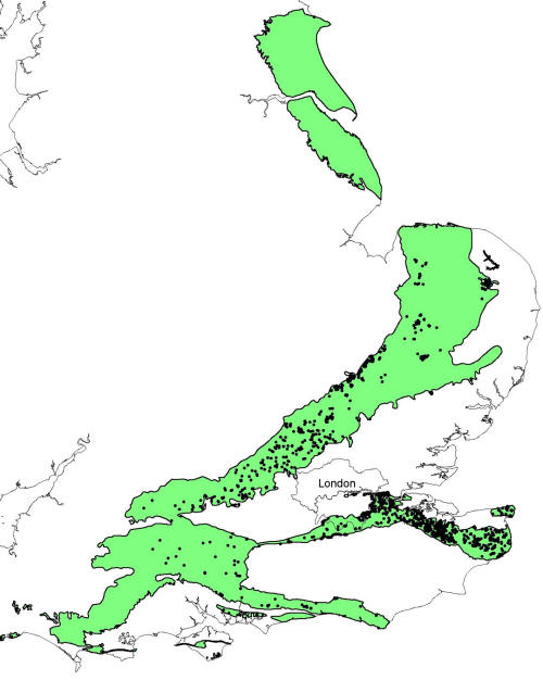
Trade Secrets

Current topics

Re: Trade Secrets

Postby macausland » 9:22 pm

It wasn't just in the Daily Wail the BBC has also reported it as well as other sites.

This site reckons it would have been easy enough to push them down a clay slipway.

http://www.archaeology.org/news/1335-13 ... -age-boats
macausland
 
Posts: 339
Joined: 3:17 pm

Re: Trade Secrets

Postby hvered » 7:50 am

The first confusion kicks in because they say South Wales and people might assume it's on the south coast, on the Bristol Channel. In fact Monmouth is many miles up river.

My instinct is that anyone clued-up about shipbuilding will look at those three channels and say "Slipway".

Monmouth is well situated for passing trade being just east of Offa's Dyke and on the Wye, seemingly the highest navigable point. I'm not sure though that a slipway automatically denotes shipbuilding.

There is a slipway on the Thames is at Medmenham. It used to be a public ford and was a rare crossing, probably toll, point. The layout is typically Megalithic; a Cistercian abbey next to the ford, a lane leading to a crossroads where the riverside road bends/narrows with a pub and a church overlooked by two 'hillforts', at least one with a hermitage.
hvered
 
Posts: 856
Joined: 10:22 pm

Re: Trade Secrets

Postby Boreades » 8:44 am

hvered wrote:
The first confusion kicks in because they say South Wales and people might assume it's on the south coast, on the Bristol Channel. In fact Monmouth is many miles up river.

My instinct is that anyone clued-up about shipbuilding will look at those three channels and say "Slipway".

Monmouth is well situated for passing trade being just east of Offa's Dyke and on the Wye, seemingly the highest navigable point. I'm not sure though that a slipway automatically denotes shipbuilding.


That's part of the confusion, because the glacial lake they are talking about no longer exists. At some point a land barrier was breached and the lake drained away down the Wye. At the time the archaeos are talking about the lake would have been isolated from the Wye itself. So it's not clear if the shipbuilding was for the lake, the river, or both.
Boreades
 
Posts: 2113
Joined: 2:35 pm

Re: Trade Secrets

Postby Boreades » 8:48 am

It could be log-launching, from forestry around Monmouth, and floating the logs down the river Wye.
Boreades
 
Posts: 2113
Joined: 2:35 pm

Re: Trade Secrets

Postby spiral » 7:27 am

Mick Harper wrote:With both rivers eroding the land between them at a rapid rate it is inconceivable that the present situation could have been arrived at if the two rivers had been left to their own devices. If then this is recent there must be at least a prime facie possibility of human intervention.


In general, orthodoxy seems quite happy to accept accept extensive chalk mining in Kent and Norfolk, yet your "Westerners" appeared not to have noticed the benefits of chalk (except for giant horsey pictures).

Probably doesn't fit the celtic myth.
spiral
 
Posts: 228
Joined: 8:10 pm

Re: Trade Secrets

Postby spiral » 7:53 am

White horse.......Orthodoxy has this the wrong way round. What is being celebrated is the chalk not the horse.
spiral
 
Posts: 228
Joined: 8:10 pm

Re: Trade Secrets

Postby Boreades » 9:27 am

spiral wrote:
Mick Harper wrote:With both rivers eroding the land between them at a rapid rate it is inconceivable that the present situation could have been arrived at if the two rivers had been left to their own devices. If then this is recent there must be at least a prime facie possibility of human intervention.


In general, orthodoxy seems quite happy to accept accept extensive chalk mining in Kent and Norfolk, yet your "Westerners" appeared not to have noticed the benefits of chalk (except for giant horsey pictures).

Probably doesn't fit the celtic myth.


We can ignore the ortho-archaeos. If you want proper evidence, talk to engineers. Like the Geological Society (Engineering Group)'s survey of chalk and flint mines.

Image

There are no mines recorded in the Chalk of Yorkshire and Lincolnshire. Southwards in East Anglia the chalk mines tend to be located in and around major urban centres such as Norwich. The rural mines are associated with flint extraction such as Grimes Graves, near Thetford and Lingheath, near Brandon. To the southwest, across the Chiltern Hills, the chalk has been mined to provide building Stone (e.g. Totternhoe), to make whiting (e.g. Kintbury), for lime burning (e.g. Hatfield) and for use in the manufacture of bricks, tiles and pottery (e.g. Reading). In the west in Wiltshire and Salisbury Plain almost no mines are known. Hampshire contains small numbers of mines (e.g. Andover) and also Devon (e.g. Beer). Eastwards along the South Downs are concentrations of flint mines associated with ancient hill forts (e.g. Cissbury Ring). South of London, along the Hog’s Back, a few mines are associated with urban centres (e.g. Guildford). Others occur within certain parts of London, especially Bexley, Blackheath, Bromley, Pinner and Woolwich. Large numbers of chalkwells and deneholes are found along the North Downs to the Isle of Thanet, and in Essex (e.g. Grays).

http://www.ukgeohazards.info/pages/eng_ ... _occur.htm

But even that is incomplete, as there are plenty of chalk quarries in Wiltshire (for example, the one behind my house). You don't need to dig a mine when the whole hillside above you is made of chalk and flint!
Boreades
 
Posts: 2113
Joined: 2:35 pm

Re: Trade Secrets

Postby Boreades » 9:32 am

Sadly the Geological Society (Engineering Group) hasn't published a similar survey for limestone quarrying and mining. Portland Bill and Box near Bath being famous examples that spring to mind.
Boreades
 
Posts: 2113
Joined: 2:35 pm

Re: Trade Secrets

Postby hvered » 9:40 am

Inhabitants on the Isle of Thanet were apparently builders of 'sea gates', openings in the chalk cliffs to give access to the sea. Worth everyone's while to keep the openings open.

The white cliffs of Dover or somewhere nearby were on TV the other night, the point made was that in places where they were overgrown the cliffs weren't terribly white. This is of course what the scouring of the white horse achieves, it's only visible from a distance when white. But I wonder how quarry sites in the chalk belt are located, it doesn't take long for the entire area to grass over.
hvered
 
Posts: 856
Joined: 10:22 pm

Re: Trade Secrets

Postby Mick Harper » 11:04 am

Extract Thirty-Five

But of course in our present state of knowledge of how landscapes come about the evidence will always be equivocal. We are obliged to turn to historical evidence for ‘Megalithic’ clues. A good one is to be found on the largest island in Poole Harbour, Brownsea Island, famous for being the first Boy Scout camp in the world. Rather more importantly there is a Michael's Mount on it, towards the western end:

Image

We can be reasonably certain that Poole Harbour was the site of ancient metal mining because melanterite was ‘mined’ there in the sixteenth century and melanterite is a hydrated iron sulphate nearly always found where mining deposits and surface water have come into contact.

Also this area is associated with the birth of the modern (ie sixteenth centrury AD) British alum industry and alum is known to be of crticial importance in ancient times, though quite why this textile whitening agent should loom so large is a matter for speculation.

The Piddle valley contains some remarkable early history. For instance Hinton St Mary has a 4th Century church in the Byzantine style which had a synagogue attached! The Piddle itself is a leat, i.e. canalised for industrial purposes, in several places, for instance here at Piddletrenthide

Image

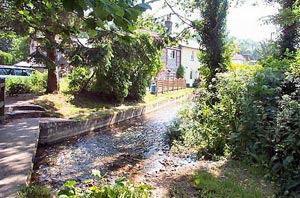
and here at Piddlehinton

Image
Mick Harper
 
Posts: 929
Joined: 10:28 am

PreviousNext

Return to Index

Who is online

Users browsing this forum: No registered users and 4 guests