Trade Secrets

Current topics

Re: Trade Secrets

Postby hvered » 10:34 am

Sandy beaches start round about Poole westwards, the shore to the east is almost all shingle. However, according to someone on this site http://www.proto-english.org/ the name Dover means 'two sands' or 'two ofers' and is Germanic.

There appears to be a thin strip of sand at low tide in this photo, if the name really does mean double sandy beach it could be the tides, allowing access to the strand of sand, that are the important feature.

Image

But a name that ignores the white cliffs seems a bit perverse!
hvered
 
Posts: 856
Joined: 10:22 pm

Re: Trade Secrets

Postby spiral » 6:02 pm

hvered wrote:Sandy beaches start round about Poole westwards, the shore to the east is almost all shingle. However, according to someone on this site http://www.proto-english.org/ the name Dover means 'two sands' or 'two ofers' and is Germanic.

There appears to be a thin strip of sand at low tide in this photo, if the name really does mean double sandy beach it could be the tides, allowing access to the strand of sand, that are the important feature.

Image

But a name that ignores the white cliffs seems a bit perverse!


I like Proto but the River is Dour and these words (Dover, Dour) just look like variants of Door.
spiral
 
Posts: 228
Joined: 8:10 pm

Re: Trade Secrets

Postby macausland » 8:37 am

'I like Proto but the River is Dour and these words (Dover, Dour) just look like variants of Door.'

One of the Cornish words for water and river is 'dowr' with variations.

http://www.howlsedhes.co.uk/cgi-bin/diskwe.pl

Although why the place would be called after a generic name for water or river, or even urine, is rather strange.

Everybody would be doing it who lived by the sea.

Perhaps place names are made for what is unusual rather than what is usual and commonplace?
macausland
 
Posts: 339
Joined: 3:17 pm

Re: Trade Secrets

Postby Mick Harper » 2:56 pm

Extract Forty-Four

There are various other places along the northern French coast between Brehat and Cape Finistère that require exploration with Megalithically-tinted spectacles but since this would be more of the same, and in any case might be better left to French investigators, we might concentrate on Finistère itself.

Finistère of course means end-of-land which is fair enough in any language to describe the very western end of the French landmass. Not surprisingly the Spanish take the same view and have named their furthest western point Finisterre. The English have followed the same idea and come up with Land’s End at their westernmost point.

However, these three places have another hidden toponymic connection. The Spanish Finisterre is in the Kingdom of Leon, the French one in the county of Léon and England's Land's End is in the (fabled, sunken?) land of Lyonesse. Just to rule out a highly improbable set of coincidences, the westernmost part of the navigably significant Channel Islands is Lihou Island and the even more significant Cadiz, at the south-western extremity of the whole European landmass, is on the island of Leon.

What does all this mean? First of all, since we have a variety of local languages and cultures coming up with the same name, we can reasonably conclude that the western littorals of England, France, Spain and the Channel Islands must at some time have been linked by a force sufficiently influential to give a common term to apparently significant but widely dispersed political units.

Secondly, we can be reasonably sure of the nature of this ‘influential common force’ because the most important thing about these western extremities is that they are ‘lee-shores’ that is the most dangerous places of all when sailing in an environment that has westerlies and south-westerlies as the prevailing wind, as is the case when sailing anywhere near England, France, Spain and the Channel Islands.

Just as the cry 'Land Ho!' is still extant in English we might plausibly assume that 'Lee Ho!' is the specialised cry to warn of these dangerous places. So Leon, Leon, Lihou, Lyonesse are all references to the most important lee shores over a wide but sometime unified navigable area.
Mick Harper
 
Posts: 929
Joined: 10:28 am

Re: Trade Secrets

Postby Mick Harper » 7:26 pm

Extract Forty-Five

The Breton headland ought to be a Megalithic hotspot and certainly the Brest complex looks at first to be a combination of the Poole Harbour and Plymouth Sound types:

Image

However there are such formidable difficulties getting in and out at all states of the tide that the presumption must be that this was treated indeed as a ‘lee-shore’. At the very westernmost edge is both a tidal island, Lédénes de Molène, and a tidal race of sixteen knots (!) which seem both highly Megalithic and yet inimical to Megalithic seafaring.

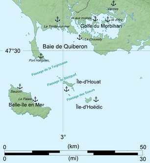
It is only once this treacherous headland is rounded that a thoroughly Megalithic safe haven is arrived at in the form of Quiberon which is both a causewayed tidal island (though not since the coming of the railway) and a highly Poole-like Golfe de Morbihan:

Image

If this is a case of Megalithic engineering, then the requisite sandy shores seem to be present and correct:

Image

But should there be doubts that this truly is a Megalithic Centre then the fact that Carnac, the world’s most impressive array of megalithic standing stones, stands rather precisely at the other end of the causeway, should banish them:

Image
Mick Harper
 
Posts: 929
Joined: 10:28 am

Re: Trade Secrets

Postby Mick Harper » 12:10 pm

Extract Forty-Six

It is around here, in South Brittany, that the salt industry begins. Although we have been concentrating on tin and suchlike high value cargoes, there is little doubt that the real engine of trade in this part of the world (and to a large extent everywhere in the ancient world) is salt.

It is pretty much the only necessity of life that has to be transported over fair distances, either from the sea or from salt mines. Since salt is a relative bulk cargo, distances from producer to consumer is critical and it would seem that this part of the French coast is the furthest north for the economic evaporation of saltwater naturally by the sun as opposed to the very expensive business of boiling brine in saltpans.

Everywhere to the north becomes a potential market if transport costs can be kept to a minimum. Not only is economic transport a Megalithic speciality so too is salt production by evaporation given the need for hydraulic control of the sea to do it.

Not surprisingly then that Noirmoutier is positioned here, a centre of saltmaking, ancient and modern, and an obviously Megalithic island, being (before modern changes) a causewayed tidal island on a causewayed tidal island.

Image

The Passage du Gois is a paved-over sandbank with a length of 4.5 kilometers connecting the island to the mainland and which is flooded twice a day by the high tide.

The island has the usual set of Megalithic connections, for instance the monastery was founded by St Filibert who was educated by St Ouen, the patron saint of Normandy and having the largest bay on Jersey named for him. Though perhaps more intriguing is the fact that a monastery founded by Noirmoutier monks on the mainland opposite is dedicated to Saint-Michel-en-l’Herm, Herm being a reference to Hermes who in turn is a version of Michael.
Mick Harper
 
Posts: 929
Joined: 10:28 am

Re: Trade Secrets

Postby hvered » 1:03 pm

Moutier is apparently an archaic word for monastery but it should mean sheep-farmer (mouton = sheep) or shepherd, for which only berger exists in French (cf. auberge meaning 'inn' or drovers' rest). Tidal islands may not be directly associated with sheep, though several islands have sheep names; monasteries of course are almost always involved with sheep and in the case of the Cistercians built up an extensive sheep-farming network.

Noirmoutier's monastery was said to be founded by St Philibert who is supposed to have given his name to filiberts, i.e. hazelnuts so he was probably a hermit. St Philibert was "educated by Saint Ouen" according to Wiki, the patron saint of Normandy. Ouen crops up in the north-west of Jersey, where St Ouen's Bay is the largest sandy beach in the Channel Islands and takes up almost the entire west coast of Jersey; it seems to be a version of Owen, Gwen or Evan.
hvered
 
Posts: 856
Joined: 10:22 pm

Re: Trade Secrets

Postby Boreades » 5:44 pm

Or Ewan or Euan.
Boreades
 
Posts: 2113
Joined: 2:35 pm

Re: Trade Secrets

Postby Mick Harper » 9:58 am

Extract Forty-Seven

This particular “West Coast” route ends at the twin islands of Ile de Re and Ile d’Oleron:

Image

The Bay of Biscay at this point becomes too rough for routine voyages so, as we shall see, alternative arrangements for serving the southern French and northern Spanish coastal areas come into play here.

Generally speaking, tin exports from Britain to the far south -- Spain, Portugal and the Mediterranean -- go direct from Brittany to the north-west corner of Spain, which is presumably why they have the same name Finistere and Finisterre, reminiscent of the direct route from Corbiere/Guernsey to Corbiere/Jersey.

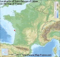
The overall position can be seen here (the two islands are marked by the red spot):
Image

The Ile de Re certainly looks entirely Megalithic:

Image

which is confirmed in a backhanded sort of way by the historical evidence:

During Roman times, Île de Ré was an archipelago consisting of three small islands. The space between the islands was progressively filled by a combination of human activity (salt fields gained from the sea) and siltage.

though whether there once was a tidal causeway is unclear:

Image

Oleron is less obviously Megalithic but has two possible sites of ancient causeways.

Image

Both islands are 'salt islands' and therefore can be assumed to be trading points in their own right but their true significance comes from the fact they guard respectively two of France's most important inland waterways. Ile de Re marks the mouth of the Charente River:

Image

And Oleron the even more important Gironde/Garonne system:

Image
Mick Harper
 
Posts: 929
Joined: 10:28 am

Re: Trade Secrets

Postby Mick Harper » 5:35 am

Extract Forty-Eight

Because of the unsuitability of the Bay of Biscay for maritime trade, there is a Megalithic land route from the most convenient navigable point on the Gironde (probably Bordeaux) and the northwest corner of Spain, where the direct Brittany (or as may be, Cornwall) traffic arrives. This route is nowadays best known as the Compostela Pilgrimage:

Image

Not surprisingly, the point at which the Compostela land route finally joins up with the Megalithic sea route, at Santiago de Compostela, is rather spectacular:

Image

This arm of the sea is called the Ria de Arousa and the Island of Arousa has a clear Megalithic outline best summed up in this picture.

Image

It will be observed that the Ria de Arousa is of the same pattern as Plymouth Sound and certainly geographers have given them the same term ‘ria’ meaning a non-glaciated drowned valley. Indeed the academic term comes from the Galician (a variant of rio meaning river) because there are five rias along this very short stretch of coastline, the Rías Baixas in Galician.

But since Galicia, like Plymouth Sound, was also a well known source of metals in the ancient world the alternative explanation, that these five rias might not be entirely natural but the result of Megalithic tidal mining techniques should not be ruled out. There may or may not be a natural explanation for why the sediment and invertebrates of the rias are even today so heavily polluted with metals.
Mick Harper
 
Posts: 929
Joined: 10:28 am

PreviousNext

Return to Index

Who is online

Users browsing this forum: No registered users and 3 guests